圣胡安堡与帝国边界:贝里遗址所见的殖民历史过程
Fort San Juan and the Limits of Empire: Colonial Encounters at the Berry Site
罗宾·贝克 Robin Beck
(沃伦·威尔逊学院 Warren Wilson College)
大卫·摩尔 David Moore
(沃伦·威尔逊学院 Warren Wilson College)
克里斯托弗·罗丁 Christopher Rodning
(杜兰大学 Tulane University)
芮切尔·布瑞格 Rachel Briggs
(北卡罗来纳大学教堂山分校 University of North Carolina-Chapel Hill)
引言
当第一次走过贝里遗址时,你会惊讶的发现,它竟是如此的平凡。贝里遗址位于一片田地的东部边缘,与其他许多遍布美国北卡罗莱纳州西部山麓的遗址没有什么不同,那里是一片广阔而富饶的平原,被阿巴拉契亚山脉包围着。与贝里遗址两侧接壤的是上游河,卡托巴河上游的一条支流,与贝里遗址一样,在名称和外观上都毫不起眼。另外两侧是观赏性林场,环抱着一片玉米田。上游河对岸的地里也种植了树木和灌木。如今,只有遗址的低洼部分每年开垦出一小块菜园,种植玉米、南瓜、豆类、黄瓜、西红柿、瓜类、土豆,甚至西兰花,其余土地都休耕。在贝里遗址,没有硕大土墩可以攀爬,也没有宽阔的广场可以穿越。与北美一些更上镜的遗址相比,当你走到贝里遗址的时候,你会发现这里其实并没什么好看的。
但在地表之下,在犁具无法触及的地方,我们在贝里追寻的故事的确令人赞叹。贝里是美国原住民小镇约拉的所在地,1566年12月27日,即布道者圣约翰日那天,西班牙船长胡安·帕尔多建立了圣胡安堡及其毗邻的殖民地昆卡,昆卡以他在卡斯提尔省的家乡命名。圣胡安堡垒是欧洲人在现在的美国内陆定居第一个落脚点,也是北美第一个见证全球化诞生的地方之一。帕尔多派30名士兵驻守堡垒要塞,在随后18个月里,他们大部分时间都与当地居民保持着良好的关系,当地人为西班牙人提供了大部分的食物和日常用品。然而,到了1568年春天,约拉人和圣胡安人之间的关系严重恶化。此时当地的印第安人以及其他六个横跨卡罗莱纳州的城镇的印第安人连同田纳西州东部(帕尔多修建堡垒的地方)的印第安人共同起义并且摧毁了西班牙的驻军。从此,西班牙再也没有尝试在佛罗里达(曾包括美国东南部大部分地区)的内陆定居,使之变成真空状态,为未来几个世纪英国移民的剥削提供了便利。
约拉和圣胡安堡
16世纪上半叶,西班牙探险家们曾多次企图殖民现在的美国东南部地区,但均以失败告终。最后,在1565年至1566年间,佩德罗·梅内德斯·德阿维莱斯成功地在南大西洋海岸建立了两个殖民地,1565年9月在佛罗里达州建立的圣奥古斯丁和1566年4月在今南卡罗来纳州的帕里斯岛建立的圣埃琳娜,后者将成为梅内德斯殖民愿望的重点地区。当腓力二世得知这一胜利后,便下令增援新殖民地。1566年7月,船长胡安·帕尔多带领250名士兵抵达圣埃琳娜巩固殖民地。然而,由于圣埃琳娜殖民地在很长一段时间内都没能好好供养这支庞大的队伍,梅内德斯命令帕尔多调集一半的军队,准备远征大西洋海岸的内陆地区。帕尔多的任务是勘察这些地区,在安抚当地印第安人的同时宣告这些土地属于西班牙,并且找到一条从圣埃琳娜到墨西哥北部银矿的陆路路线。于是,1566年12月1日,帕尔多便带着125名士兵出发了。
月末时,帕尔多和他的手下沿着沃特伊河和卡托巴河穿过了卡罗来纳州皮埃蒙特市,来到了约拉,这是一个坐落在卡托巴河流域的大型土著城镇,靠近阿巴拉契亚山脉东部边缘。根据记载,约拉的首领是“Joara Mico” (Mico是当地人对地区首领的称呼)。他有权力领导着卡托巴河上游及其支流附近的一些城镇。帕尔多把一个小镇改名为昆卡,昆卡是他在西班牙的家乡。他还在约拉建造了一座名叫圣胡安的堡垒,并派了30名士兵驻守在那里。尽管早期的探险队已经在内陆建立了季节性的营地或已经临时占领了当地的城镇,帕尔多仍然光明正大地建造了圣胡安堡,将圣埃琳娜殖民地扩展到佛罗里达州的北部边境。就这样,他在现在的美国内陆建立了最早的欧洲殖民地。后来,帕尔多又建立了五个前沿哨所,但圣胡安堡垒仍是他整个帝国规划的中心。
西班牙士兵在约拉的18个月里,大部分时间都与这个小镇的居民保持着友好的关系,例如,西班牙人至少两次协助当地的战士在田纳西州和弗吉尼亚州的阿巴拉契亚山脉袭击敌对土著首领。此外,在帕尔多准备离开堡垒进行第二次远征时,他命令其士官阿尔贝托·埃斯库德罗·德·维拉马尔 “判断并维护当地所有酋长和印第安人的友好关系”。然而,就在帕尔多1567年11月离开后的几个月,圣胡安堡和约拉人之间的关系就出现了灾难性的恶化。1568年5月,传到圣埃琳娜的消息称,印第安人袭击并摧毁了帕尔多的所有堡垒,包括圣胡安堡。可能导致此次反抗行动的因素有几个,但最突出的两个是:士兵对食物的需求和他们对当地妇女的不当行为。最后,130名士兵和帕尔多所有的堡垒都被摧毁,而西班牙最后一次企图殖民佛罗里达北部边境的行动也随之失败。事实上,在一个多世纪之后,其他欧洲人才深入到阿巴拉契亚山脉南部。
贝里遗址考古
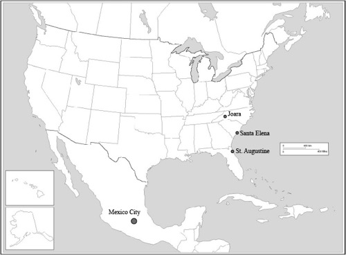
考古学和历史学证据表明,贝里遗址(31BK22)是约拉和圣胡安堡的所在地。贝里位于卡托巴河上游的一条支流上游河,即现在的北卡罗来纳州伯克县。遗址占地约4.5公顷,位于上游河与爱尔兰河交汇处一个75公顷的冲积洼地东侧边缘。考古证据表明,贝里是史前晚期卡托巴河流域上游最大的遗址之一。赛勒斯·托马斯在1894年通过史密森学会民族学研究所发表了有关土墩勘探的报告,这是历史上第一次对这个遗址进行描述。这个土墩及其周边都是定期清理的,而且在1950年前的某个时期,为了填补一个遭受侵蚀的低洼地区,这个土墩被推平了。我们的研究持续了22个田野季度,或者说是120周的考古发掘与调查。
在16世纪,贝里遗址(如约拉)位于密西西比文化圈的东北边缘和西班牙殖民地西北边疆。贝里是某个密西西比酋邦的政治中心,是大约从公元1000年到1600年里大陆中部和东南地区诸多同类型政体的中心之一。通过对贝里遗址南部和北部进行的系统调查,发现了26处密西西比陶器遗址,其中多处遗址可能与贝里属同一个时期。我们认为附近的这些考古遗址是贝里政权的核心,同时把印第安人占领卡托巴河上游和亚德金河的这段时期称为伯克时期(公元1400-1600年)。田野工作包括对这个面积为5公顷的遗址的大部分地方进行系统的地面收集和坡度测量。发掘面积超过1750平方米,但重点关注一个1.5公顷的区域。这是个建筑群,我们在此发现了大量西班牙陶瓷、五金工具和军事用品,还发现了一组五栋烧毁了的建筑物。我们确认这就是是昆卡,并称之为西班牙建筑群,这是圣胡安遗迹组成部分的防御工事。我们在这两个方面的研究为跨大西洋的帝国和殖民主义考古学研究提供了独特的见解。
西班牙建筑群
在这个 “西班牙建筑群”里有五个巨大柱状固定结构,其中四个建在半地下的盆地里,但均被烧毁。到目前为止,我们已经研究了其中的两座建筑,即建筑1和建筑5。对它们的发掘和分析为我们了解其工程建筑提供了大量的数据。1号建筑是两者中较大的一个,侧面测量结果为7.5米(约56平方米),是4个建在盆地里的建筑之一。类似的盆地在整个阿巴拉契亚山脉南部地区以密西西比文化晚期的建筑为典型,实际上,1号建筑的大部分结构似乎也是该地区本土风格建筑的代表。它包含1个中央火膛,4个巨大而深入的内部支撑,和位于建筑一角延伸出去的通道作为明确的入口。但是占地49平方米的5号建筑却不那么具有典型的本土建筑风格。尽管它也包含一个与1号建筑相似的中央火膛,但它不是建造在盆地中的,其入口通道也不明显,难以识别。它的四个核心支柱伫立在很浅的柱坑中,无法为其屋顶提供足够的支撑,因此后来又增加了两个内部支柱以稳定建筑。这两个建筑里保存完好的有机样品为金属工具的使用和欧式木工手艺在木材采伐、前期准备、建造方面提供了清晰的证据。这些样品包括1号建筑的锯木和栗树木板,5号建筑的木板条,以及来自这两座建筑的样品上的钉子洞。这两座建筑连同其他三座仍未被发掘的建筑被同时烧毁,并且没有任何证据显示它们曾被重建过。
自1986年以来,我们已经在贝里遗址发现了200多个坑并挖掘了其中的60多个。我们已确认和发掘的坑大部分都位于西班牙建筑群里。考虑到空间的限制,我们的目标不是描述所有的发掘过的坑,而是关注其中出土的样本,包括欧洲手工艺品或者一些很可能来源于非原住民文化的铜器碎片。迄今为止,我们已经在这个范围内清理出16个这样的坑,并细分为两种明显不同的类型,分别称之为中心坑和西区坑。其中大部分可能是在房屋建造过程中作为涂饰材料处理坑开始的,随后便填满了生活垃圾。5号建筑附近的其他堆积里也包含垃圾。
根据考古现场和实验室数据,我们确定了西班牙建筑群的两个主要建筑阶段。第一阶段在遗址的北部边缘附近建造了1号、3号和4号三个略微呈弧状分布的建筑。我们相信,第一阶段的开始时间与1566年12月下旬帕尔多抵达约拉的时间相吻合。并且从建筑1复原的数据,特别是欧洲与当地的木工手艺和工程建筑的融合来看,在圣胡安堡被占领初期士兵与原住民是相互合作的。事实上,1567年9月,当帕尔多在第二次远征期间返回约拉时,他在冬天来临前留下了30名士兵。公证人胡安·德拉班德拉记录道:“他发现了一座新的木屋,上面有一个装满玉米的高架房,这是部落酋长为服务陛下而根据首领的命令建造的。”76号坑位于中心坑东部边缘的附近,里面有一个直径为66厘米、深约10厘米的圆形壁炉,在西班牙建筑群的早期可能是一个露天厨房。
在被占领的第二个阶段,2号和5号建筑建在了第一阶段建筑的同一轴线偏西15到20米处,这两个新建筑都占领了中央坑,具有一定的先后关系。关于2号建筑,我们本应介绍更多,因为到目前为止,我们仅仅探索了它的南部一角和部分东墙。但是,在1997年进行的奥格尔(Augur)测试首次发现所有建筑时,表明了这些建筑与该建筑群其它半地下建筑有相同的形状和大小。此外,检测表明,2号建筑的沉积物深度与1号、3号和4号建筑的沉积物深度差不多,也就是说,2号建筑似乎是建在一个和其他建筑一样深的盆地里。然而,5号建筑是一个例外,我们认为在该建筑群使用的第二阶段,它被用作正式的炉台或者厨房,取代了76号坑的露天厨房。5号建筑在该建筑群中比较特别,但与其它西班牙殖民遗址的厨房相似。它既靠近垃圾处理坑,也靠近一大片堆肥场,这是该建筑群中发现的唯一一处类似堆肥场的遗存。
圣胡安堡
我们在这个建筑群的广泛工作为了解这一殖民冲突的日常活动提供了信息。圣胡安堡的士兵大部分时间都是在这里度过的。他们在这里睡觉、吃饭、互相交往或与约拉的男人女人建立人际关系,他们在这里遵循着日常生活的习惯和常规。在我们过去几年的考古田野工作中,感到难以捉摸的仍然是有关防御工事本身的证据,就是圣胡安堡究竟在哪里?
在其他早期殖民地遗址,这样的生活区域通常在空间特征上有别于防御工事。也就是说,在遭受殖民统治的地方,生活空间与其公共或防御区域之间是保持隔离的。1588年,约翰·史密斯的报告称,在罗阿诺克岛被遗弃三年后,在岛内发现了拉尔夫·莱恩的殖民地。他写道,“堡垒中有几年前他手下建造的各种必要且体面的住宅。”对于1564年在佛罗里达建立的法国卡罗琳堡垒的描述也表明,其住房均建造在堡垒之外。随着在2013年发现了圣胡安堡,我们现在意识到这种生活区与公共或防御区的明确划分同样适用于贝里遗址。我们确信,帕尔多驻军的地方,在被西班牙短暂占领之前和之后占主体地位的还是大量的当地风格的建筑。
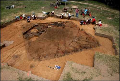
自2014年以来,我们已从圣胡安堡的考古现场中移除了约240平方米的犁耕地带(图6)。这些犁耕地带的土壤中包含的西班牙文物和美洲原住民文物与从西班牙建筑群中发现的文物数量相似,然而,在堡垒内部及其附近次犁耕地带的土壤极为复杂,我们对此也知之甚少。这主要是因为不管是在圣胡安堡垒被占领之前,占领之时,还是占领之后,遗址的这一部分地区曾有过一系列广泛的活动。理解在这个极具争议的土地上权力和反抗的社会关系,是我们在下一个阶段的研究中力求解决的关键问题。在次犁耕环境中,我们可以看见许多坑,有些十分有趣。其中一个就是位于堡垒西南象限的大圆形坑,直径约1米。值得注意的是,它被由水沉积物组成的不规则晶状体包围着,因此,这个坑很可能是一口井。
就在这个坑的北面,有一个长方形的单体建筑(7号建筑),由于护城河的北面和西面均经过此地,该建筑应比堡垒更早建成。其内部的几根大柱子可能用于支撑屋顶,两个疑似火膛的坑位于建筑的中心附近。在堡垒内部北面边缘还有几个坑,包含厚厚的粘土沉积物(254号坑),其面积为30平方米,深6厘米(取决于耕作深度)。这个坑由一种干净的黄棕色粘土构成,这种粘土在遗址的其他地方均没有发现。似乎是有意为之,且与矩形的柱子建筑平行排列。与这种粘土相邻的是一个类似贝丘的沉积坑(255号坑),类似于我们在西班牙建筑群西部发现的贝丘。要解释堡垒内部的这些沉积坑,尤其是要确定哪一个坑出现在被西班牙占领之前,哪一个坑出现在被西班牙占领之后和哪一个坑出现在被西班牙占领的时候,需要更广泛而深入的考古工作。而且对于我们来说,这的确是一个令人激动的挑战。

结论
1492年10月,哥伦布在巴哈马群岛登陆,开启了可能是人类历史上最具戏剧性的文化交流。从南美洲的火地岛到北美洲的圣劳伦斯河,跨越两大洲的美洲原住民,经受住了来自西班牙、英国、法国、葡萄牙、荷兰和其他远在欧洲最具殖民愿望的国家的探险者、定居者、传教士和奸商的殖民浪潮。在这些国家中,西班牙是目前为止,在早期的探索和征服方面最雄心勃勃的国家。
连同我们之前在西班牙建筑群内部的工作,我们在圣胡安堡正在进行的工作与北美其他考古项目一样,为人们提供了一个全面而有力的早期殖民主义视域。结合早期殖民冲突背景下的考古学和民族史资料,我们的研究将有助于从人类学角度更广泛地了解南大西洋,因为它恰好位于政治、经济和物质变革的全球化的前沿。
个人简介
罗宾·贝克是密歇根大学人类学系副教授,担任人类考古学博物馆北美考古副主任兼馆长。2004年博士毕业于美国西北大学。研究兴趣包括北美东部、玻利维亚和秘鲁的安第斯山脉中复杂社会的考古学和民族史学,现今美国东南部的早期殖民遭遇,以及一些与社会变迁长期轨迹相关的广泛话题。论著主要有:美国南方早期酋长权力、崩溃与联合》(剑桥大学出版社,2013),《耐用的房屋:考古学中的房屋社会模型》(CAI出版社,南伊利诺斯大学卡本代尔分校,2007)、合著《圣胡安堡垒和帝国的界限:贝里遗址的殖民主义与家庭习惯》(佛罗里达大学出版社,2016)。他曾在《现代人类学》、《美国人类学家》、《美洲考古》、《拉丁美洲考古》、《历史考古学》、《民族史学》、《东南考古学》等期刊上发表文章,也曾为期刊的编辑作出贡献。2006年,贝克获得了用于表彰美国东南部研究领域杰出青年学者的C. B. 摩尔奖,以表彰他在考古方面的杰出贡献。他的研究得到了国家科学基金会、国家地理学会和温纳–格林基金会的资助。
大卫·摩尔是美国北卡罗来纳州阿什维尔市沃伦·威尔逊学院的人类学教授。在加州大学伯克利分校取得了学士学位,在北卡罗莱纳大学教堂山分校获得了人类学硕士学位和博士学位。1986年,在完成了贝里遗址的论文调查之后,与同事罗宾·贝克、克里斯托弗·罗丁和芮切尔·布瑞格一同进行贝里的发掘工作。贝里遗址考古项目得到了国家科学基金会、国家地理学会和新墨西哥州圣达菲高等研究院的资助。专著有《密西西比卡托巴河流域:陶瓷、年代学和卡托巴印第安人》(阿拉巴马大学出版社,2002),与罗宾·贝克和克里斯托弗·罗宁合著《圣胡安堡垒和帝国的界限:贝里遗址的殖民主义与家庭习惯》(佛罗里达大学出版社,2016)。他还是《去往卡罗莱纳的新航程》(北卡罗莱纳大学出版社,2017)和《被遗忘的世纪:美洲南部的印第安人和欧洲人1521-1704》(佐治亚大学出版社,1994)的合著者。写的或合写的论文还曾在《东南考古学》上发表。他协助创立了约拉探索基金会,并担任其高级考古学家等,该基金会是美国东部最大的公共考古项目之一。在过去的六年里,通过在贝里遗址、地方学校、博物馆和其他公共场所的公共项目,约拉探索基金会已经为14000多人提供了服务。
克里斯托弗·罗丁是美国路易斯安那州新奥尔良市杜兰大学人类学系的教授,同时也是贝里遗址考古项目的联合负责人。1994年,以优异成绩毕业于哈佛大学,获得人类学学士学位。2004年毕业于北卡罗来纳大学教堂山分校,获得人类学博士学位。2005年,他获得了C.B.摩尔奖。2014年,在德克萨斯州奥斯汀市主持了美国考古学会(SAA)年度会议的项目委员会。目前是东南考古会议的秘书; 担任美国考古学会 (SAA)出版的《美洲考古》书评编辑;是美国考古学会的杂志《美国考古学会考古记录》的编辑。专著《中心地带和切罗基人城镇:阿巴拉契亚山脉南部印第安人建筑和景观的考古学观察》于2015年由阿拉巴马大学出版社出版,并于2019年再版平装本。以下考古人类学期刊或其它期刊上独著或合著发表论文及书评:《美国人类学家》、《美洲考古》、《历史考古学》、《东南考古学》、《北美考古学家》、《人类学考古学》杂志等,此外,他也是几本考古学学术著作的作者和合著者。他对考古学的学术兴趣包括以下主题:文化接触和殖民主义、文化景观、纪念物、建筑、仪式和宗教、混沌理论、弹性理论以及北美土著史和史前史。
芮切尔·布瑞格是美国北卡罗来纳大学教堂山分校人类学和考古学系的教学助教,也是贝瑞遗址考古项目的最新联合负责人。2005年,她在沃伦·威尔逊学院获得学士学位;2011年,在阿拉巴马大学获得人类学硕士学位;2017年在阿拉巴马大学获得人类学考古学博士学位。她的作品已经在《美洲考古》,《南方本地》以及其他期刊和刊物上发表。目前,她正与人合编一部名为《密西西比妇女》(佛罗里达大学出版社)的著作,该书主要讲述了美国东南部地区史前晚期当地妇女所扮演的动态角色。布里格斯的学术兴趣主要集中在饮食习惯、性别研究、感官体验、实验考古学、神经美食学和体验认知。尤其是她的大量研究都集中在美国东南部以玉米为基础的饮食习惯。她参与了几个正在进行的研究项目,广泛地探索研究这些饮食习惯的工具、膳食,甚至感官体验。
INTRODUCTION
What strikes you, the first time you walk across the Berry site, is how unremarkable it is. It occupies the eastern edge of a field like so many others across the western Piedmont of North Carolina, a wide expanse of rich floodplain that is hemmed in by the foothills of the Appalachian Mountains. Upper Creek—a tributary of the upper Catawba River as unremarkable in name and appearance as Berry itself—borders the site on two sides. Two other sides are edged by ornamental tree farms, with a corn field in between. The fields on the opposite bank of Upper Creek are also planted in trees and shrubs. Today, only the lower end of the site is annually plowed for small garden plots of corn, squash, beans, cucumbers, tomatoes, melons, potatoes, and even broccoli. The rest of the site lies fallow. There are no great mounds to climb at the Berry site, no wide plazas to cross. Compared with some of the more photogenic sites in North America, you might justifiably walk onto Berry and think to yourself, there is nothing to see here.
But beneath the surface, out of reach of the plows, the story we are recovering at the Berry site is, indeed, remarkable. Berry is the location of the Native American town of Joara, and it was here—on December 27, 1566, the feast day of St. John the Evangelist—that the Spanish captain Juan Pardo established Fort San Juan and its adjoining colony of Cuenca, named after his own hometown in the province of Castile. Fort San Juan was the very first European settlement in the interior of what is now the United States, and was likewise one of the first places in North America to experience the birth of globalization. Pardo garrisoned his fort with 30 men, and for much of the 18 months that followed they enjoyed good relations with their Native hosts, who supplied the Spaniards with most of their daily food and provisions. Yet relations between the people of Joara and the men of Fort San Juan had deteriorated badly by the spring of 1568, when the Indians here and at the six other towns across the Carolinas and eastern Tennessee where Pardo built forts rose up and destroyed the Spanish garrisons. Never again would Spain attempt to settle the interior of La Florida, a territory that once included most of the American Southeast, creating a vacuum that English settlers would exploit during the centuries to come.
JOARA AND FORT SAN JUAN
During the first half of the sixteenth century, Spanish explorers failed in several efforts to colonize what is now the southeastern United States. Finally, in 1565-1566, Pedro Menéndez de Avilés successfully founded two settlements on the south Atlantic Coast: San Agustín, founded September 1565 in Florida, and Santa Elena, founded April 1566 on present Parris Island, South Carolina. The latter, Santa Elena, was to be the center of Menéndez’ colonial aspirations. When Philip II learned of this success, he ordered reinforcements for the new colony. In July 1566, Captain Juan Pardo arrived at Santa Elena with a company of 250 soldiers and began to fortify the settlement. As the Santa Elena colony was ill-prepared to feed this large contingent of men for very long, however, Menéndez ordered Pardo to prepare half of his army for an expedition into the interior that lay behind the Atlantic coast. Pardo’s task was to explore the region, to claim the land for Spain while pacifying local Indians, and to find an overland route from Santa Elena to the silver mines in northern Mexico. Pardo left with 125 men on December 1, 1566.
Later that month, after crossing the Carolina Piedmont along the Wateree and Catawba rivers, Pardo and his men arrived at Joara, a large Native town situated in the Catawba Valley near the eastern edge of the Appalachian Mountains. Joara’s chief, referred to in the accounts as Joara Mico [Mico was a native term for regional chief], held authority over a number of neighboring towns along the upper Catawba River and its tributaries. Pardo renamed this town Cuenca, after his own native city in Spain. At Joara, he built a fort, San Juan, which he garrisoned with thirty men. Although earlier expeditions into the interior had constructed seasonal encampments or had temporarily occupied native towns, Pardo explicitly built Fort San Juan to expand the Santa Elena colony into the northern frontiers of La Florida. In so doing, he established the earliest European settlement in the interior of what is now the United States. Pardo would go on to build five other outposts, but Fort San Juan was to be the center of his imperial designs.
Over most of the eighteen months that Spanish soldiers lived at Joara, amicable relations existed between the people of this town and their European guests–on at least two occasions, for example, the Spaniards accompanied native warriors in attacks on hostile native chiefs across the Appalachians in Tennessee and Virginia. Also, when Pardo was preparing to leave the fort during his second expedition, he commanded its ensign, Alberto Escudero de Villamar, to “judge and have a care of the conservation of the friendship of the caciques and Indians of all the land.” Yet in the months that followed Pardo’s departure in November 1567, relations between Fort San Juan and the people of Joara took a calamitous turn for the worse. By May 1568, news reached Santa Elena that Indians had attacked all of Pardo’s forts, including Fort San Juan, and that all were destroyed. Several factors may have played a role in this aggressive action, but two stand out: the soldiers’ demands for food and their improprieties with native women. In the end, 130 soldiers and all of Pardo’s forts were lost, and with them Spain’s last attempt to colonize these northern frontiers of La Florida. Indeed, it was more than a century before other Europeans are known to have penetrated this far into the southern Appalachians.
ARCHAEOLOGY AT THE BERRY SITE
Archaeological and historical evidence indicate that the Berry site (31BK22) is the location of Joara and Fort San Juan. Berry is situated along Upper Creek, a tributary of the upper Catawba River, in what is now Burke County, North Carolina. The site covers about 4.5 ha and is located along the eastern margin of a 75 ha alluvial bottomland at the junction of Upper and Irish creeks. Archaeological evidence indicates that Berry was one of the largest late prehistoric sites in the upper Catawba Valley. The site was first described in Cyrus Thomas’ 1894 report on mound explorations by the Smithsonian’s Bureau of Ethnology. The mound and the surrounding site were both regularly plowed, and sometime before about 1950 the mound itself was bulldozed to provide fill for a low-lying area that was subject to erosion. Our research extends over 22 field seasons or more than 120 weeks of excavation and archaeological survey.
In the sixteenth century, the Berry site (i.e., Joara) sat at the northeastern edge of the Mississippian cultural world and at the northwestern edge of Spain’s colonial frontier. Berry was the political center of a Mississippian chiefdom, one of many similar polities in the Midcontinent and Southeast from circa A.D. 1000-1600. Systematic surveys north and south of Berry have identified 26 sites with Mississippian pottery, and many of these were probably contemporaneous with Berry. We suggest that these nearby archaeological sites are the core of Berry’s polity, and we refer to this period of Native American occupation along the upper Catawba and Yadkin rivers as the Burke phase (A.D. 1400-1600). Our fieldwork at the Berry site has included systematic surface collection and gradiometer survey over most of the 5 ha site. Excavations total more than 1750 m² and concentrate on the 1.5 ha area where we have recovered a substantial assemblage of Spanish ceramics, hardware, and military items in association with both a compound of five burned buildings—which we identify as Cuenca and refer to as the Spanish Compound—and a fortification that constitutes the remains of Fort San Juan. Our research in these two contexts is offering unique insights into the archaeology of empire and colonialism across the Atlantic frontier.
THE SPANISH COMPOUND
The Spanish compound contains five large, set pole structures, four of which were built in semisubterranean basins and all of which were burned. To date we have investigated two of these buildings, Structures 1 and 5, excavation and analysis of which provide much of the data for our understanding of construction practices. Structure 1, the larger of the two, measured 7.5 m on a side (about 56 m²) and was among the four structures built in basins. Such basins were typical of Late Mississippian architecture throughout the South Appalachians, and indeed most of Structure 1 seemed typical of indigenous-style architecture in the region. It contained a central hearth, four large and deeply placed interior supports, and a well-defined entry with exterior trenches on a corner of the structure. Structure 5, measuring 49 m², was less typical of native architecture. While its central hearth was similar to that of Structure 1, it was not constructed in a basin, its entryway could not be identified, and its four central posts were placed in very shallow postholes, such that they that offered insufficient support for the structure’s roof–two additional interior posts were later added to stabilize the structure. Remarkably preserved organic samples from both buildings provide clear evidence both of metal tool use and European-style carpentry practices in wood harvesting, preparation, and construction. These include sawn timbers and a sawn chestnut plank from Structure 1 and wood slats from Structure 5, as well as spike or nail holes in samples from both buildings. Both buildings, along with the three that remain unexcavated, were burned to the ground at the same time, and there is no evidence that any was ever rebuilt.
Since 1986 we have identified more than two hundred features at the Berry site, of which we have excavated more than sixty. Most of the features we have identified and excavated are inside the Spanish compound. Given space constraints, our goal here is not to describe all excavated features, but rather to focus on the sample of features containing European artifacts or copper fragments that probably derive from non-aboriginal sources. To date, we have excavated 16 such features inside limits of the compound, which we have subdivided into two distinct clusters we refer to as the central features and the western features. Most of these probably began as daub processing pits during the process of house construction, after which they were filled with domestic trash. Others represent midden deposits near Structure 5 that also contain refuse.
Based on field and laboratory data, we have identified two phases of primary construction activity in the Spanish compound. In the first phase, three structures—1, 3, and 4—were built in a slightly curving arc near the northern edge of the site. We believe that the beginning of this first phase coincides with Pardo’s arrival at Joara in late December 1566, and data recovered from Structure 1, in particular the blending of distinct native and European carpentry and construction practices, suggests that this early period of the fort’s occupation was characterized by cooperative relations between the soldiers and their indigenous hosts. Indeed, when Pardo returned to Joara during his second expedition in September 1567, having left 30 men there the winter before, notary Juan de la Bandera recorded that “he found built a new house of wood with a large elevated room full of maize, which the cacique of the village…had built by the command of the captain for the service of His Majesty.” Feature 76, a circular hearth 66 cm in diameter and about 10 cm deep, was situated near the eastern edge of the central features and may have served as an open-air kitchen during the early phase of the compound’s use.
During the second phase of occupation, Structures 2 and 5 were built together along the same axis 15 to 20 m west of the first phase structures. Each of the two new structures intrudes into the central pit features, establishing the temporal priority of the latter. We may say little more about Structure 2, since as yet we have only exposed its southern corner and a portion of its eastern wall. Augur testing conducted in 1997, however, when the structures were all first discovered, indicates that this building has the same shape and size as the other semisubterranean structures in the compound. Moreover, these auger tests revealed that deposits in Structure 2 are similar in depth to those of Structures 1, 3, and 4; that is, Structure 2 seems to have been built in a basin of about the same depth as these others. Structure 5, then, is an anomaly, and we suggest that it was used as a formal cocina or kitchen during the compound’s second phase, replacing the open-air kitchen associated with Feature 76. Alone among the five structures in the Spanish compound, but like kitchens at other Spanish colonial sites, Structure 5 was adjacent both to refuse disposal pits and a large sheet midden, the only such deposit identified in the compound area.
FORT SAN JUAN
Our extensive work in the compound area has informed the domestic side of this colonial encounter. It was here that the soldiers of Fort San Juan would have passed much of their time. It was where they slept, ate their meals, developed personal relationships with one another and with the men and women of Joara, and where they followed the habitual and routine practices of daily life. What remained elusive, in all of our previous years of archaeological fieldwork, was evidence of the fortification itself—where was Fort San Juan?
At other early colonial sites, such living areas were often spatially distinct from defensive works. That is, separation was maintained between the domestic spaces of the colonial encounter and its public/defensive zones. In 1588, John Smith reported finding Ralph Lane’s settlement on Roanoke Island some three years after its abandonment. Its fort, he wrote, had “sundry necessary and decent dwelling houses made by his men about it the yeere before.” Depictions of French Fort Caroline, established in Florida in 1564, also showed its houses located beyond the fort itself. With our discovery of Fort San Juan in 2013, we now know that such a formal division of domestic and public/defensive space likewise pertains at Berry. We have also determined that the space Pardo appropriated for his garrison was occupied by substantial Native structures both before and after the relatively brief interval of its Spanish use.
Since 2014 we have removed approximately 240 m² of plowzone from the archaeological footprint of Fort San Juan (Figure 6). These plowzone soils contain similar quantities of Spanish and Native American artifacts as were recovered in the Spanish compound, but the sub-plowzone soils in and around the fort are extremely complex and as yet poorly understood, due primarily to the extraordinary range of activities that took place in this portion of the site before, during, and after the occupation of Fort San Juan. Understanding the social relations of power and resistance embedded within claims and counterclaims to this contested space is a key problem we seek to address through the next phase of our research. Numerous features are visible in the sub-plow matrix, and some of these are quite intriguing. One is a large circular pit in the southwest quadrant of the fort that measures about 1 m in diameter. Significantly, it is surrounded by irregular lenses of water-borne sediment and likely represents a well.
Just north of this feature is a rectangular single-post building (Structure 7) that predates the fort’s construction, as it was intruded by both the northern and western sides of the moat. Several large posts inside this structure probably represent roof supports, and two likely hearth features are located near the center of the building. There are additional features along the northern edge of the fort’s interior, including a thick clay deposit (Feature 254) that extends over an area of 30 m² and is much as 6 cm deep depending on depth of plowing. It consists of a clean, yellow-brown clay found nowhere else on the site. A seemingly intentional deposit, it is also aligned parallel to the rectangular post building. Adjacent to this clay is a midden-like deposit (Feature 255) that resembles the midden we identified in the western portion of the Spanish compound. Interpreting these deposits on the interior of the fort—especially determining which predate, postdate, or were contemporaneous with the Spanish occupation—will require far more extensive excavations, and indeed, this is a challenge that excites us all.
CONCLUSIONS
Columbus’ landfall in the Bahamas in October 1492 initiated what was perhaps the most dramatic century of cultural exchange in human history. Over two continents, the native peoples of the Americas—from Tierra del Fuego to the St. Lawrence River—withstood waves of explorers, settlers, proselytizers, and profiteers from Spain, England, France, Portugal, the Netherlands, and other distant centers of European colonial aspiration. Of these nations, Spain was by far the most ambitious in its early efforts at exploration and conquest.
Together with our previous work in the domestic Spanish compound, our ongoing work on Fort San Juan is providing as comprehensive and robust a view of early colonialism as any other archaeological project in North America. By combining archaeological and ethnohistorical data on the contexts of this early colonial encounter, our research promotes a broadly anthropological understanding of this South Atlantic frontier on the cusp of those political, economic, and material transformations wrought by globalization.
Biographic Sketch
Robin Beck is Associate Professor in the Department of Anthropology at the University of Michigan and serves as Associate Director and Curator of North American Archaeology in the Museum of Anthropological Archaeology. He received his PhD from Northwestern University in 2004. Beck’s research interests include the archaeology and ethnohistory of complex societies in eastern North America and the Andes of Bolivia and Peru, early colonial encounters in what is now the southeastern United States, and the broader issues related to long term trajectories of social change. He is the author of Chiefdoms, Collapse, and Coalescence in the Early American South (Cambridge University Press, 2013), editor of The Durable House: House Society Models in Archaeology (CAI Press, SIU Carbondale, 2007), and co-editor of Fort San Juan and the Limits of Empire: Colonialism and Household Practice at the Berry Site (University Press of Florida, 2016). He has published articles in Current Anthropology, American Anthropologist, American Antiquity, Latin American Antiquity, Historical Archaeology, Ethnohistory, and Southeastern Archaeology and has also contributed to numerous edited volumes. In 2006, Beck received the C. B. Moore Award for Excellence in Archaeology by a Young Scholar in Southeastern Studies. His research has been supported by grants from the National Science Foundation, the National Geographic Society, and the Wenner-Gren Foundation.
David G. Moore is a professor of anthropology at Warren Wilson College, Asheville, North Carolina, USA. He earned a B.A. from the University of California, Berkeley, and M.A. and PhD. in anthropology from the University of North Carolina at Chapel Hill. Following his dissertation investigations at Berry in 1986, he was joined by colleagues, Robin Beck, Christopher Rodning, and Rachel Briggs, for ongoing excavations at Berry. The Berry Site Archaeological Project has been supported by grants from the National Science Foundation, the National Geographic Society, and the School for Advanced Research in Santa Fe, New Mexico. Professor Moore is author of Catawba Valley Mississippian: Ceramics, Chronology, and Catawba Indians (University of Alabama Press, 2002), and co-editor with Robin Beck and Christopher Rodning of Fort San Juan and the Limits of Empire: Colonialism and Household Practice at the Berry Site (University Press of Florida, 2016). He is coauthor of chapters in New Voyages to Carolina (University of North Carolina Press 2017), and The Forgotten Centuries: Indians and Europeans in the American South 1521-1704 (University of Georgia Press 1994), and has authored and coauthored articles in Southeastern Archaeology. He helped to found, and serves as the Senior Archaeologist for, the Exploring Joara Foundation, Inc., one of the largest public archaeology programs in the eastern United States. Over the past six years, the Exploring Joara Foundation has reached more than 14,000 people through public programs at the Berry site, at regional schools, and at museums and other public venues.
Christopher B. Rodning is professor in the Department of Anthropology at Tulane University, New Orleans, Louisiana, USA, and codirector of the Berry Site Archaeological Project. Professor Rodning was graduated magna cum laude from Harvard University with a B.A. in anthropology in 1994, and a Ph.D. in anthropology from the University of North Carolina at Chapel Hill in 2004. He is the 2005 recipient of the annual C.B. Moore Award for an Outstanding Young Scholar in the Archaeology of the Southeastern U.S., and he chaired the program committee for the annual conference of the Society for American Archaeology (SAA) in Austin, Texas, in 2014. He is currently secretary of the Southeastern Archaeological Conference; the book reviews editor for American Antiquity, the journal published by SAA; and editor of the SAA magazine, the SAA Archaeological Record. His book, Center Places and Cherokee Towns: Archaeological Perspectives on Native American Architecture and Landscape in the Southern Appalachians, was published by the University of Alabama Press in 2015, and reissued in paperback in 2019. Rodning is author and coauthor of scholarly papers and book reviews in American Anthropologist, American Antiquity, Historical Archaeology, Southeastern Archaeology, North American Archaeologist, the Journal of Anthropological Archaeology, and other journals, and he has also been author and coauthor of chapters in several scholarly books in archaeology. His scholarly interests in archaeology include topics such as culture contact and colonialism, cultural landscapes, monuments, architecture, ritual and religion, chaos theory, resilience theory, and the history and prehistory of Native North America.
Rachel V. Briggs is a teaching assistant professor at the University of North Carolina-Chapel Hill, USA, in the departments of anthropology and archaeology, and the newest co-director of the Berry Site Archaeological Project. She received her BA from Warren Wilson College in 2005, her MA in anthropology from the University of Alabama in 2011, and her PhD in anthropological archaeology from the University of Alabama in 2017. Her work has been featured in American Antiquity and Native South, as well as other journals and edited volumes. Currently, she is working on a co-edited volume, Mississippian Women (University Press of Florida), which focuses on the dynamic roles native women performed in the late prehistoric period in the Southeastern United States. Briggs’s scholarly interests primarily lie in foodways, gender studies, sensory experiences, experimental archaeology, neurogastronomy, and embodied cognition. In particular, a great deal of her research has focused on maize-based foodways throughout the Southeastern United States, and she is engaged in several on-going research projects that broadly explore the tools, meals, and even sensory experiences of these foodways.