苏格兰奥克尼群岛布罗德加的尼斯遗址
The Ness of Brodgar, Orkney, Scotland
尼克·卡尔德 Nick Card
(英国高地与群岛大学 University of Highlands and Islands Archaeology Institute)
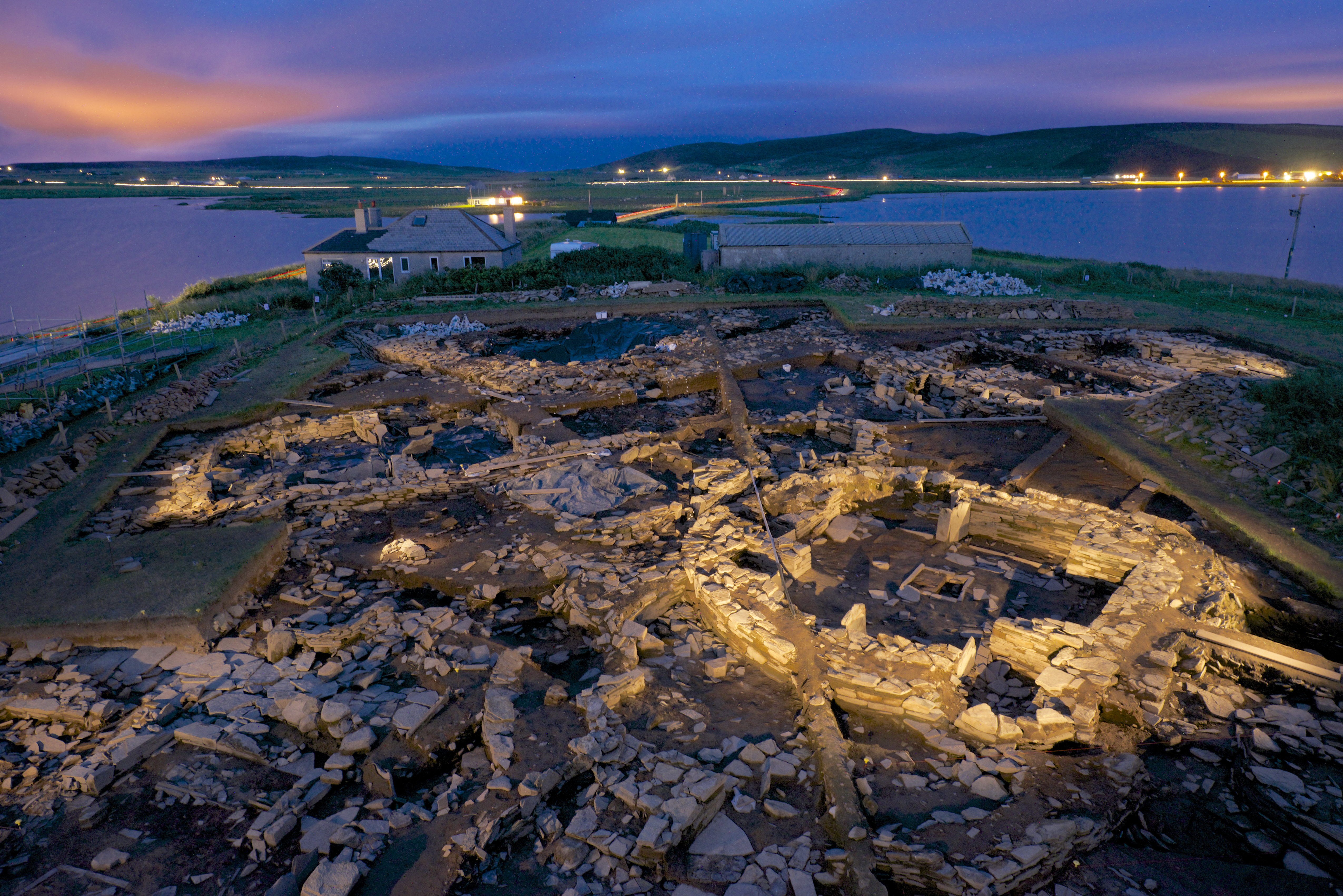
布罗德加的尼斯(http://www.nessofbrodgar.co.uk)是位于奥克尼新石器时代世界遗产(WHS)中心地带的一处独特遗址。它坐落于苏格兰北端的奥克尼群岛中心地带的一块狭长海角上,这里是北欧古迹分布最为密集的地区之一。它与梅肖韦墓群(Maeshowe)都位于布罗德盖石圈(the Ring of Brodgar)和斯丹尼斯立石(the Stones of Stenness)之间。该墓群可能是近处可见的欧洲最好的新石器时代石室墓。
直到2002年这个遗址才因成为一项重大地球物理计划的一部分而被发现,该计划旨在将这个新指定的世界遗产纳入到更广泛的范畴之中。这一计划探测出尼斯的两块土地地表异常集中。结果的复杂性意味着需要考古发掘来辅助解释。2003年,农田耕作过程中偶然发现了一个大的缺口板,这成为推动田野发掘的催化剂。在发现地点周围的初期发掘过程中发现了一个棱角分明且对称的室内墙角支墩,其风格与20世纪80年代在附近新石器时代村庄巴恩豪斯(Barnhouse)发现的一个建筑结构非常类似。
为了进一步弄清地球物理性质并评估未来潜在的农业损失,(科研人员)随后进行了几个季度的试掘工作。(人们)很快认识到,海角的大鲸背脊(面积约2.5公顷,高5米)——一个巨大的古墓式的遗存,并非自然景观,而是人类活动的结果,这意味着新石器时代人类长期在此活动。从那时起,在高地与岛屿大学考古研究所和布罗德加尼斯信托基金会管理下,每年都会进行大规模区域发掘(但仅占遗址总面积的10%不到)。发掘表明,这里地层堆积深厚,分期复杂,年代跨越了英国北部整个新石器时代(约3500-2400BC),但也有迹象表明中石器时代早期和铁器时代晚期也有人类在此活动。结构序列反映了在家庭范围内其他地方看到的建筑风格变化,这些建筑是早期具有直立分隔的椭圆形建筑;其次是房屋,这些房屋的床嵌入墙壁中,到了晚期房屋的床则凸出到地板上。但是布罗德加尼斯遗址建筑的不同之处在于它们的设计和规模都过于夸张。
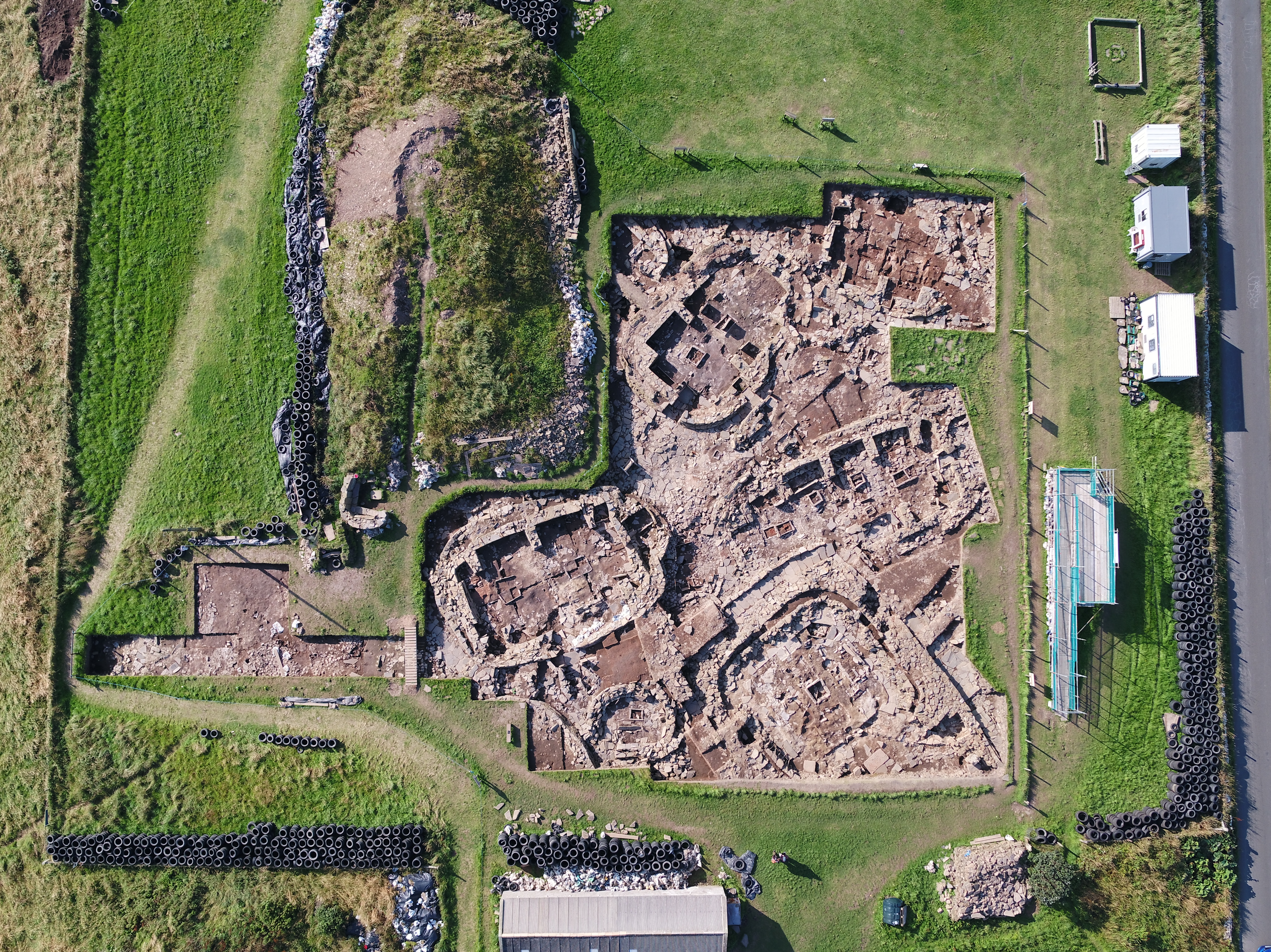
目前正在调查该遗址的主要阶段(大约3200—2400 BC),此时尼斯流行大型独立的建筑,部分被巨大的石墙所包围。目前发现的大多数建筑都有一个共同的建筑结构,由相对立的石墩划分内部空间,但除了这个基本的共同特征之外,规模和工艺呈多样化。这些差异可能意味着不同群体的工作,每个群体都希望在布罗德加尼斯中占有一席之地,群体之间存在着竞争。
总体而言,保存方面非常出色,保存下来的墙壁的高度超过了一米,这清楚地展示出新石器时代石匠对原料的了解及应用的熟稔。虽然大部分石头来自当地的采石场,但有些彩色砂岩是从几公里外开采来的。这些结构不仅在内部以其棱角分明的、对称的建筑而显得特别,而且外部也是如此,屋顶上覆盖着规则的石板瓦—这一技术至今仍在奥克尼使用。良好的保存现状允许我们对每座建筑物进行准确的记录和描绘,尽管它们经历了改建、改动,甚至改变了功能。
虽然乍一看,这些建筑几乎是随机排列的,但它们的组织结构有一定的次序。有些是围绕着一个由南北走向的立石组成的中心区域布置的,而另一些则参照遗址上的其他立石来定位,并且在某些情况下,它们与罗盘的基点对齐。排水系统也暗示了一定程度的规划,该排水系统位于建筑物底部和周围,并将污水汇入一个大型中央排水沟。
毫无疑问的是,北欧(及其他地区)的新石器时代社会是聚集、聚居在重要古迹周围并围绕其运行的。我们还知道,随着时间的推移各个古迹经常被维护或提及,并围绕它们多次举行集会。因此,奥克尼世界遗产区也是如此,它以墓葬和其他公共仪式场所都的集中而久负盛名。布罗德加尼斯遗址之所以如此重要,是因为它为我们提供了一个机会,让我们了解在这片景观的中心到底发生了什么。布洛德加半岛和周围土地这一整个“碗(碗状洼地)”被尼斯(遗址)占据着。它似乎对诸如布罗德加石圈(the Ring of Brodgar)、斯丹尼斯立石(the Stones of Stenness)和梅肖韦古墓(Maeshowe)等古迹所见证的事件至关重要。从幸存下来的特殊沉积物来看,它也有其自身的意义,对于分散在奥克尼群岛(甚至很可能更远)的新石器时代族群来说,此地极其重要且具有社会意义。
虽然测年项目表明这些片段性的活动有1200年以上的历史,但该建筑群的全部性质和历史尚未完全确定。然而,很清楚的是,布罗德加的尼斯的结构或建筑特点使它有别于该地区的其他地方。那些在参观过附近地区新石器时代(遗址)的人应该知道布罗德加尼斯大多数建筑物的组合方式;他们自己的房屋也是类似选择的结果。他们不熟悉的是建筑的规模;个别建筑物和围墙的真正不朽性质。他们也会在复杂的环境中遇到时间穿越的戏剧感。除此之外,我们还发现了大量的人工制品和骨骼组合、彩陶、来自英国各地的奇异材料(包括一种产自苏格兰西南部的类似黑曜石的沥青石、来自英格兰北部湖区斧头工厂的斧坯,以及与巨石阵风格相似的陶器);弄清了许多建筑物的内部结构;明确了有选择地使用的彩色建筑石材;发现了有颜料的绘画以及850多件新石器时代艺术品(超过英国其余地区的总和)。尤其是其艺术的非凡性,因为在这样的纪念性建筑群中,有很多东西是在特定的环境中幸存下来的,这确实罕见。很多艺术作品只有爱尔兰的遗存才能与之相媲美,这再次重申了布罗德加尼斯遗址与不列颠群岛存在广泛的联系。
所有这些都意味着此地不是家庭聚落。在其主要阶段,尼斯似乎是一个来自奥克尼和其他地方人们的聚会之所,他们在这个充满活力的社会的中心参与交换、宴会、炫耀性消费,并庆祝重要事件。
高层次活动也反映在英国最大的新石器时代土丘中,它直径超过70米,现高超过4米,位于半岛最顶端,围墙的外面,主要包含与文化遗存混杂在一起的灰烬和垃圾。土丘的规模似乎是经过了深思熟虑,反映了此地的富足和地位,作为一个炫耀性消费的地方,也是尼斯重要性的象征。
尽管在主探沟中遇到的结构很奢侈,但密封在这个巨大土丘下面的却是结合了许多特殊特征的另一种结构,即27号建筑(Structure 27)。这是一处大型长方形建筑,尽管石材遭到严重劫掠,但(仍可以看出)它内外都进行了精心装饰。连长达4.55米由斜石支撑的竖石也被装饰了。目前这座建筑物是独一无二的。地板层尚未清理,但它可能相当于石质的奥卡迪亚(Orcadian)式建筑(一个大型的新石器时代木质大厅),尽管石雕的精致与完美和遗址中最后的主要建筑(10号建筑)有很多共同的地方。
虽然大多数早期建筑仍在使用,但10号建筑(建于公元前2950年左右)在其规模(总体约19米宽,20多米长)、布局结构和预设的社会组织方面与这些建筑明显不同。虽然与斯卡拉布雷(Skara Brae)的新石器时代房屋的晚期风格具有相似之处,但10号建筑在各个方面都显示出住宅的宏大化,或在英国被称为“大房子”的样貌。在附近的巴恩豪斯(Barnhouse)村也看到了类似的情形,其中8号建筑的建造与布罗德加尼斯遗址的10号建筑最接近。
其基本构造是圆角方形小房间,由厚达4.5米的仪式墙隔开, 室内使用了许多不同颜色的砂岩板,也有几块立石,环绕着铺就的小路,门道入口与梅肖韦古墓(Maeshowe)及春/秋分日出在一条线上。
和遗址中的其他晚期建筑一样,10号建筑遭受了下陷(归咎于底层较早建筑)——西南角在最初建造的一两代内就倒塌了(或故意为之?),但其结构得到了重建和大规模改造(大约公元前2850年)。因为增加了角落支墩,中央房间在平面上变成了十字形,在这些支墩下发现了一些特殊奠基,包括一个雕刻的石球、一块装饰华丽的大石头和一块人臂骨。这些支墩可能仅仅是一种结构上的需要,以防止后续的不稳定,但也可以被视为在石头上反映了奥克尼郊外一些大型新石器时代晚期建筑物中以及确实在梅肖韦古墓(Maeshowe)的主室中发现的四个柱位。在尼斯遗址中,对10号建筑的这种改造与现存的早期建筑功能的变化相吻合,大部分建筑被改造,一些在本质上变得更加实用或半工业化。与早期建筑风格的变化一样,这意味着另一个重大的社会变化。
尼斯遗址最后灭亡发生在第三个千年的后半段。10号建筑建筑被部分拆除,填充其内部后形成一个类似石堆的土堆。其他建筑物的遗迹被填满了垃圾,从人们的视线中消失了。在对石头进行系统掠夺之前,最后一步是在10号建筑周围放了至少400头牛的遗骸。这是纪念活动还是新秩序的庆祝活动?这一事件大致与之前奥克尼更大范围的组织网络崩溃同时发生,极少出现的早期青铜时代陶制高脚杯就是证明。一块陶制高脚杯残片和一个放置在牛骨上方的、典型的早期青铜时代的带翼和铤的燧石箭头,对于探索尼斯的灭亡是一个有趣的线索。无论尼斯在上个千年通过它的各种化身代表了什么,这一切都黯然失色。
所有这些因素使布布罗德加尼斯成为一个我们期待可以发现更多证据,以改变我们对新石器时代社会生活和社会变化认知的地方。与最近在杜灵顿墙(Durrington Walls)和巨石阵(Stonehenge)进行的工作相比,该遗址展示出人们在北岛及其周围地区建造世界的具体材料和历史条件的潜力。它可以与横跨大西洋欧洲的其他序列相比较,增加我们对该地区发展的理解,并在更大范围内揭示了联系和沟通的本质。
布罗德加尼斯的发掘主要是一个研究项目,它与世界遗产(WHS)的研究议程、苏格兰考古研究框架(ScARF)的报告、教科文组织的条件和世界遗产组织的管理计划主题相符,但它也积极追求社区和公众的高水平参与。我们鼓励志愿者参与发掘及后续工作。邀请公众参观工地,参加我们的免费导览和特殊开放日,在高架平台上观看现场发掘,并利用众多的解说牌,也可以满足专家和学校团体的需要。发掘工作可以通过我们每天的在线图文日记和社交媒体加以了解。这吸引了数百万的点击量。来自世界各地的学生和志愿者参加我们的田野学校,而学生可以加入我们的“考古发掘俱乐部”。发掘结果通过各种媒体进行发布,包括电视、广播、互联网、印刷品等,并针对学术界和民众的各种兴趣层次进行量身定制。
作为一项研究项目,(我们)在发掘现场和发掘后都大量采用了新技术,包括摄影测量、古地磁测年、便携式XRF地面分析、基于无人机的多光谱测量和摄影、激光扫描、GIS、三维建模、残留物分析、微形态、RTI摄影等,精细的地球物理调查运用了一系列的技术和“智能动物群(Smartfauna)”(该技术可以使用激光扫描和摄影测量对复杂骨沉积中的任何图案进行高度精确的三维空间分析)。这些都为呈现出一个整体的尼斯遗址做出了重大贡献。
尼斯的高知名度和曝光率也为奥尼克郡当地的经济做出了巨大贡献。这不仅通过筹集资金进行发掘(主要是通过向为支持该项目而设立的两个慈善机构提供全球捐款),而且还通过旅游业(促进发掘),旅游业是奥克尼仅次于农业的第二大经济部门。随着布罗德加尼斯闻名世界,考古已经成为游客来奥克尼的首要原因—这被称为“布罗德加尼斯效应”。
作者简介
从格拉斯哥大学毕业后,尼克在英国各地开展了广泛的工作。在过去的20年里,他为奥克尼考古研究中心指导并管理了大量的项目,该中心隶属于他协助建立的苏格兰高地与岛屿大学考古研究所。
他一直是UHI的荣誉研究员;奥克尼世界遗产研究委员会成员;特许考古学家学会会员;苏格兰古文物学会会员;布罗德加尼斯信托基金会主席和美国布罗德加尼斯之友副主席。
自从奥克尼世界遗产被题名以来,他一直参与相关遗址的研究和实地工作:是布克安古墓(Bookan Chambered Tomb)发掘工作的负责人;是WHS地球物理学方案的协调人,也是研究议程的主要贡献者。他的兴趣在于英国史前和高地及岛屿的各个方面,特别是关于新石器时代。
自2004年以来,尼克指导的布罗德加尼斯发掘与研究工作获得了国际认可,包括《国家地理》的封面文章在内的广泛报道,并获得了多个奖项,包括美国考古学会的认可、当前年度考古研究项目以及国际安达特旅行考古奖。
他在英国和国外做过很多演讲。2017年,他被美国考古学会授予克雷斯(Kress)巡回讲学资格,在美国各地讲学。
The Ness of Brodgar (http://www.nessofbrodgar.co.uk) is a unique, Neolithic complex in the Heart of Neolithic Orkney World Heritage Site (WHS). It is situated on the Orkney Islands off the northern tip of Scotland, on a thin isthmus at the centre of one of the richest archaeological landscapes in northern Europe. It lies midway between the stone circles of the Ring of Brodgar and the Stones of Stenness, with Maeshowe, possibly the finest Neolithic chambered tomb in Europe visible in the near distance.
The site was only discovered in 2002 as part of a major geophysical programme intended to put the monuments of the newly designated World Heritage Site into their wider context. This revealed a dense concentration of anomalies covering the two fields at the Ness. The complexity of the results meant that excavation would be required to aid their interpretation. The following year the chance discovery of a large notched slab during ploughing acted as a catalyst for ground-truthing the results. Initial trenching around the find spot revealed a very angular and symmetrical corner buttress within a building, which was remarkably similar in style to one structure discovered at the nearby Neolithic village of Barnhouse excavated in the 1980s.
To further clarify the nature of the geophysics and assess the potential of further agricultural damage, several seasons of trial trenching followed. It soon became apparent that the large whaleback ridge of the isthmus (circa 2.5 hectares in area and rising to circa 5m high), till then considered to be a natural feature in the landscape, was mainly the result of human activity – a large tell-like mound representing many generations of Neolithic activity. Since then there have been annual, large-scale area excavations (but still covering less than 10% of the overall site), managed by the University of the Highlands and Islands Archaeology Institute and the Ness of Brodgar Trust. This has revealed a deeply stratified, multi-phase complex spanning the whole of the Neolithic period of northern Britain circa 3500- 2400calBC, but with indications of both earlier Mesolithic and later Iron Age activity. The sequence of structures reflects changing styles of architecture seen elsewhere in the domestic sphere, from early oval buildings with orthostatic divisions, followed by houses with bed recesses built into walls, and latterly houses with beds projecting into the floor area. But the Ness buildings are also different in that they are of an exaggerated form, both in their scale and complexity of design.
In the main phases (circa 3,200 – 2,400 calBC) presently under investigation the Ness was dominated by many large, freestanding buildings partly enclosed by massive stone walls. Most of the buildings presently uncovered share a common architecture, of opposed stone piers defining internal space, but beyond this basic shared feature they are of a large range of size and finesse of build. These differences may imply the work of different communities, each wishing to have a presence at the Ness, and reflecting competition between these groups.
Overall the preservation is outstanding with walls surviving to over a metre in height, which clearly show the mastery of the Neolithic masons in their understanding of their raw material and its selection. Although much of the stone comes from local quarries, some of the coloured sandstone has been extracted from locations many kilometres away. Not only did these structures appear special internally with their angular, symmetrical architecture, but also externally for their roofs were covered in regular stone slates – a technique still used in Orkney today. The quality of preservation also allows accurate biographies of each building to be constructed, as they were remodelled, altered and their function changed.
Although on first appearance the buildings seem almost randomly laid out, there is a certain order to their organisation. Some are arranged around a central paved area with a north-south aligned standing stone, while others are located with reference to other standing stones on the site and in some instances aligned on cardinal points of the compass. A level of planning is also implied by the drainage system that underlies and surrounds most of the buildings and feeds into a large central drain.
It is no revelation that the Neolithic in North-Western Europe (and elsewhere) saw societies gather, cohere and turn around important monuments. We also know that individual monuments were often sustained or referenced over time, repeated gatherings marked by a legacy of monument complexes. So, it is with the World Heritage Area in Orkney, long recognized for the remarkable concentration of tombs and other places of public ceremony. What makes the Ness so important is that it offers us a chance to understand what went on at the hub of this landscape. The entire ‘bowl’ of the Brodgar peninsula and surrounding land turns on the area occupied by the Ness. It seems to have been pivotal to the events witnessed at monuments like the Stones of Stenness, Maeshowe or the Ring of Brodgar. And from the exceptional deposits that survive, it also had a significance of its own, as a place that was important and socially pivotal for the Neolithic communities scattered around the Orkney archipelago and (most likely) even further afield.
The full nature and history of the complex is not yet fully established although dating programmes indicate over 1200 years of episodic activity. However, it is already clear that the structural/architectural character of the Ness of Brodgar sets it apart from other places across the region. Those visiting the immediate area in the Neolithic would have recognized the ways that most of the buildings on the Ness were put together; their own homes were the result of similar choices. What they would not have been familiar with was the scale of the structures; the truly monumental nature of individual buildings and enclosing walls. They would have also been confronted by a dramatic sense of time depth in the complex. To this we can add the evidence of extensive artefact and bone assemblages, coloured pottery, exotic material from across Britain (including pitchstone, an obsidian like material from south-west Scotland, axe blanks from the axe factories of the Lake District of northern England, and ceramic styles most closely paralleled in the Stonehenge area); the interior fabric of the many buildings; the selective use of coloured building stone; painting with pigments and a rich corpus of over 850 examples of Neolithic art (more than the rest of the UK in its entirety). The art in particular is truly remarkable because much survives in context, which is very rare in such monument complexes. Much of the art is only paralleled by examples from Ireland, again reiterating the wide network of contacts the Ness had across the British Isles.
All this implies that this was no domestic settlement. During its main phases it seems it was a place for the coming together of people from across Orkney and beyond, where they took part in exchange, feasting, conspicuous consumption, in celebrations of the important events, central to this vibrant society.
The high level of activity is also reflected in the largest Neolithic midden mound in the UK, over 70m in diameter and presently over 4m high, at the very tip of the peninsula just outside the walled enclosure. This is comprised mainly of ash and midden intermingled with cultural material. The scale of the mound seems to make a deliberate statement, reflecting the affluence and status of the site, and as a place of conspicuous consumption: a symbol of the importance of the Ness.
Although the structures encountered in the main trench are extravagant, sealed below this huge midden mound is another structure that combines many unusual features, Structure 27. This is a large sub rectangular building that, although badly robbed of stone, is not only exquisitely finished externally but also internally, where it was clad in orthostats partly supported by prone orthostats up to 4.55m long. Presently this building is unique. Floor levels have yet to be revealed but it may be the Orcadian equivalent of a large Neolithic timber hall, translated into stone. The accomplished nature and refinement of the stonework has much in common with the final major building on site, Structure 10.
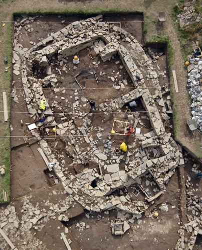
Although most of the earlier period buildings remained in use, Structure 10 (built circa 2950cal BC) was a marked departure from these in terms of its scale (overall circa 19m wide by 20+m long), layout architecture, and presumed social organisation. Although sharing similarities with the later style of Neolithic house as at Skara Brae, in every respect Structure 10 displays the monumentalisation of the domestic or what has been referred to in the UK as a ‘big house’. A similar trajectory is seen at the nearby Barnhouse village with the construction of building number 8, the closest parallel for Structure 10 at the Ness.
In its primary form it had a sub-square chamber with rounded corners defined by monumental walls up to 4.5 m thick, that internally utilised many pick-dressed slabs of sandstone of different colours. It incorporated several standing stones in its build, had a surrounding paved pathway, and a forecourt area and entrance aligned with Maeshowe and the equinox sunrise.
Like the other late buildings on site, Structure 10 suffered from subsidence (due to underlying earlier buildings) – its south-western corner collapsed within a generation or two of its initial construction (or was it by intentional demolition?), but the structure was rebuilt and extensively remodelled (circa 2850 cal BC). Its central chamber became cruciform in plan with the addition of corner buttresses, under which special votive foundations were found including a carved stone ball, a substantial, richly decorated stone and a human arm bone. These buttresses might be viewed as merely a structural necessity to counter further instability but can also be seen as reflecting in stone the four post settings found in some large late Neolithic buildings outside of Orkney, and indeed in the central chamber of Maeshowe. At the Ness this remodelling of Structure 10 coincides with a change of function of the surviving earlier period buildings, with most of them being remodelled and some becoming more utilitarian or semi-industrial in nature. As with earlier changes in architectural style, the implication is another major social change.
The final demise of the Ness occurs in the latter part of the third millennium. Structure 10 is partially demolished and the interior infilled to create a cairn like mound. The remains of other buildings are infilled with midden and obliterated from view. A final act, before systematic stone robbing, is the deposition of the remains of at least 400 cattle around Structure 10. Was this an act of commemoration or the celebration of a new order? This event roughly coincides with the apparent more widespread collapse in Orkney of previous networks evidenced by the rare occurrence of Early Bronze Age Beaker ceramics. The discovery of a single sherd of Beaker pottery and a classic early Bronze Age barbed and tanged flint arrowhead in layers just above the cattle bone deposit is an intriguing clue as to the endgame of the Ness. Whatever the Ness had represented through its various incarnations over the previous millennium this was being eclipsed.
All of these factors make the Ness of Brodgar a place where we can expect to uncover more evidence that transforms our picture of social life and social change in the Neolithic. It can contrast with recent work at Durrington Walls and Stonehenge, with the demonstrated potential to reveal the specific material and historical conditions in which people constructed their worlds in and around the Northern Isles. It can be compared with other sequences across Atlantic Europe, adding to our understanding of how things unfolded in this region, and reveal much about the nature of contact and communication at broader scales.
The Ness of Brodgar excavations are primarily a research project which fulfils themes in the WHS Research Agenda, the Scottish ScARF report, UNESCO’s conditions, and the WHS Management Plan, but the Ness also actively pursues a high level of community and public engagement. Volunteers are encouraged to participate both in the excavation and post-excavation processing. The public are invited to visit the excavations and attend our free guided tours and special open days and view the site from an elevated platform and take advantage of the numerous interpretation panels. Specialist and school groups are catered for. The excavation can be followed virtually through our daily online illustrated diary and social media. These have attracted several million hits. Students and volunteers from around the world attend our field-school, while school children can join our ‘Excavation Club’. Dissemination of the results of the excavation is through many different media including television, radio, WWW, printed articles and features and is tailored to suit all levels of interest, both academic and popularist.
As a research project the incorporation of as wide an array of new and innovative techniques during both excavation and post excavation is being implemented. This includes photogrammetry, archaeomagnetic dating, portable XRF analysis of floors, drone based multispectral survey and photography, laser scanning, GIS, 3-D modelling, residue analysis, micromorphology, RTI photography, refined geophysical survey using a range of techniques, and Smartfauna (a technique that allows the highly accurate 3D spatial analysis of any patterning in complex bone deposits using laser scanning, photogrammetry). These are all paying huge dividends in the production of an overall synthesis of the Ness.
The high profile and exposure the Ness has secured also contributes hugely to the local Orcadian economy. This is not simply through the funds raised to run the excavation (mainly by world-wide donations to the two charities established to support the project), but also via tourism which is the second largest sector of the economy of Orkney after farming. As the Ness of Brodgar has become known world-wide, archaeology has become the number one reason for tourists coming to Orkney – this has been called the ‘Ness Effect.’
Biographic Sketch
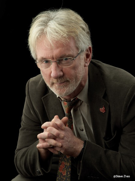
Nick has worked widely throughout Britain since graduating from Glasgow University. Over the last two decades he has directed and managed a wide range of projects for the Orkney Research Centre for Archaeology within the University of Highlands and Islands Institute of Archaeology that he assisted in establishing.
He has been an Honorary Research Fellow of the UHI; a Member of Orkney World Heritage Site Research Committee; a Member of the Chartered Institute for Archaeologists; a Fellow of the Society of Antiquarians of Scotland; Chair of the Ness of Brodgar Trust: and Vice president of the American Friends of the Ness of Brodgar.
Since the inscription of Orkney’s World Heritage Site, he has been involved in research and fieldwork relating to the sites: as director of the excavations at Bookan Chambered Tomb; as co-ordinator of the WHS geophysics programme; and as a major contributor to the Research Agenda. His interests lie in all aspects of the prehistory of Britain and the Highlands and Islands with particular reference to the Neolithic.
Since 2004 Nick has directed work at Ness of Brodgar that has become internationally recognised, reported widely including the cover article in National Geographic, and the recipient of several awards, including recognition by the American Institute of Archaeology; the Current Archaeology Research Project of the Year; and the international Andante Travel Archaeology Award.
He has lectured widely in the UK and abroad. In 2017 he was awarded the Kress Travelling Lectureship by the Archaeological Institute of America lecturing across the USA.