土耳其青铜时代赫梯文明都城考古:博阿兹考伊-哈图莎什遗址
Archaeology of the Making of a Bronze Age Capital City: Boğazköy/Hattusha through Time
安德烈亚斯·沙赫纳 Andreas Sebastian Schachner
(德国考古研究院 German Archaeological Institute)
1834年,一位叫特克西耶(Ch. Texier)的法国人发现了位于安纳托利亚博阿兹考伊村(Boğazköy)附近一个古城遗址,这是最有可能探索古代东方起源的最大古城之一。显而易见的是,亚兹勒卡亚(Yazılıkaya)有一处露天神殿,岩石上布满浮雕,这些岩画的艺术风格独一无二。尽管发现得早,但第一次大规模系统发掘是在1906~1912年,由土耳其伊斯坦布尔博物馆和德国东方学会共同负责,并将其确定为赫梯文明的古都——青铜时代晚期的哈图莎什(Hattusha)遗址。这在安纳托利亚高原恶劣的地理条件下,首次明确认定古老的东方文化起源远远超出了美索不达米亚、埃及以及印度河谷的河流区域(见图1),这次发现彻底颠覆了近东古代考古学的根本范式。
自1931年以来,德国考古研究所的考古研究工作几乎未曾间断:第一阶段(1931~1939年;1952~1977年)由库特·比特尔主持;第二阶段(1978-1993年)由彼得·内夫主持;第三阶段(1994~2005年)由尤尔根·西赫主持;第四阶段是安德烈亚斯·沙赫纳于2006年开始研究至今。同时,发现了30000多件泥板文书,绝大数用赫梯楔形文书写,仅少量用其他古代东方语言书写。基于贝德日赫·赫罗兹尼1915年对印欧语系赫梯文的新发现,建立了古代东方赫梯学学科的专门研究。经过一个多世纪的集中研究,深入建立了近东青铜时代晚期最重要的超级大国之一的历史、社会结构、物质文化和宗教相互之间的联系。考古发掘的部分成果与历史学和语言学研究相结合。为了重新唤起人类对这种完全被遗忘的文化的记忆,1986年联合国教科文组织将博格斯考伊哈图莎什考古遗址列入世界文化遗产。2001年,联合国教科文组织又将发现的楔形文字档案列入非物质文化遗产名录。所以,博阿兹考伊是唯一同时具备两项重要遗产的具有代表性的考古遗址。
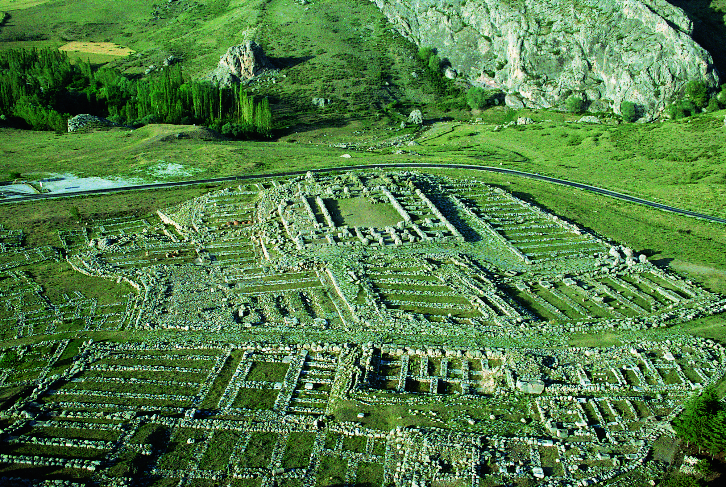
1970年以后,考古研究主要集中在古城的旧城区(下城)。旧城区有坚固的布于卡拉皇城(见图2)、大神殿(见图3)、居民楼以及最古老的防御要塞。可以确定的是,在公元前三千年末建成之后,这座城市逐渐发展成为一个大帝国的首都。1978—1993年,彼得·内夫重新定位了上城区,并在该市的部分区域发现了30多个寺庙,后来修正了年代,这在很大程度加深了对城市地形的了解。感谢尤尔根·西赫在1994~2005年的考古研究,让我们得以了解早在公元前16世纪中叶,上城基本上是根据公众代表和权力象征的标准设计的。同时,他还发现了形式各样的人工水库和几个巨大的粮仓,这对了解古城的经济供给状况作出了重要贡献。
地下粮食储藏室由皇家机构建造和掌控。在类似真空的条件下,粮仓能长时间存储大量谷物,弥补了农作物歉收的不足。粮仓储存的谷物不是为人们提供食物,而是供应牲畜,以为下一轮的农业播种蓄力。仅在城市中就发现了9个人工水库,都建在斜坡上,功能相似(见图4)。这种建筑形式确保了底部的不透水层,而其向后有每年循环的地下水升降水流流过,所以在冬季数月中,水都会流到其中。人们几乎不使用这种长期储存的水,但是它确保了牲畜的水供应,并有利于用水密集型手工业的正常运作。
通过这些杰出的工程成就,可以发现安纳托利亚许多赫梯文化古城建造形式有其共性,也为赫梯皇权的转型奠定了基础。早在公元前17世纪~前16世纪初期,安纳托利亚就形成了一个伟大的超级帝国,这对了解公元前16~前13世纪后期该区域极其重要。与赫梯文化技术创新相似的是,社会上流行学习美索不达米亚文化的赫梯语言和楔形文字,还有宗教同化以及意象和风格上统一的艺术创造都以美索不达米亚文明为标准,传达了皇家中央集权的意识形态,更有效的建立和控制整个社会(见图5)。
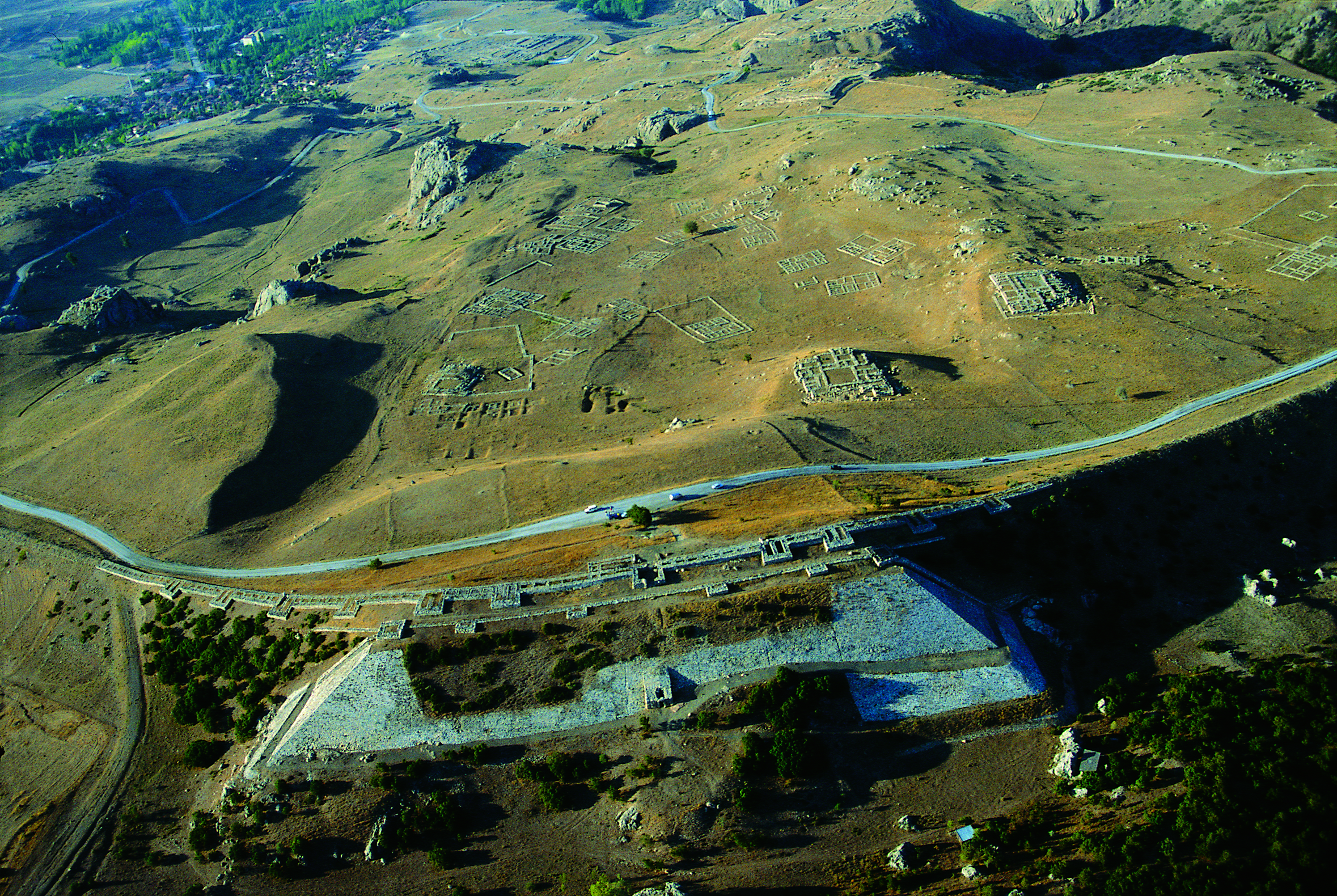
在很长一段时间里,长达数十年的研究成果传达了一个线性发展的城市形象。近来,这座城市的历史研究有了几次深刻的历史转折和重大突破。根据安纳托利亚其他地区的考古发现,特别是最近对安纳托利亚地区以外的屈尔台培遗址(Kültepe)的研究,该遗址位于叙利亚、安纳托利亚和美索不达米亚的交汇之处,首次在这座复杂城市里发现了公元前3世纪定居的证据。最初,哈图莎什地理位置占据着重要的战略意义,在交界处连接着安纳托利亚北部和中部。毋庸置疑,公元前19世纪~前18世纪亚述商人定居在安纳托利亚中部各个城市,并建立了“殖民地”,构成了当今伊拉克核心地位的贸易中心的一部分。但在过去两年中首次发现了这一时期历史悠久的建筑,这得益于皇家独裁统治的允许,有助于了解统治者的经济状况(见图6)。十分罕见的古楔形文字是哈图莎什统治者权力的政治发展需要的体现。
据推断,从亚述贸易殖民时期(公元前1950~前1730或1720年)到赫梯时期的过渡期约80年。考古发现尽管遭到了阿尼塔国王(约公元前1728年)的破坏,仍保留了相当大规模定居的考古学证据。最晚在公元前17世纪中叶,赫梯王朝与哈图西里一世夺取政权,他并没有定居在一个废弃的城镇,而是选择聚居在一个运转良好的城镇中。而从考古学的角度看,新政权开始的证据是确凿的。赫梯帝国日常的物质文化呈线性发展。新的考古发现促使我们反思并重新评估了以往的发现,表明赫梯统治者很早就开始根据其思想和社会文化需要来重塑旧城区,明显体现了安纳托利亚当地的古建筑物风格。但与亚述贸易殖民时期相比,建筑结构和用途明显不同。前17世纪末~前16世纪,最具有代表性的建筑是皇家城堡和大神庙(见图2和3)。同时,前面提到的水库和粮库奠定了全新的经济基础,在一定程度上弥补了安纳托利亚中部不确定的地理因素。
最迟至公元前1530年,哈图莎什建立了具有代表性的上城区,几乎与当代美索不达米亚和埃及首都一样,还具有相应的代表性设计和影响力(见图7)。上述发现的30多个寺庙构成了一个独立的区域。赫梯人自称寺庙可能起到了确保“千神帝国”伟大国王典礼仪式正常举行。此外,建在巨大岩石高原上的寺庙建筑显然起到了祖先崇拜的重要作用,可能是对死者和国王神化的直接证据。当然,寺庙的建立、保护和定期祭祀也是统治阶级合法化的重要组成部分。
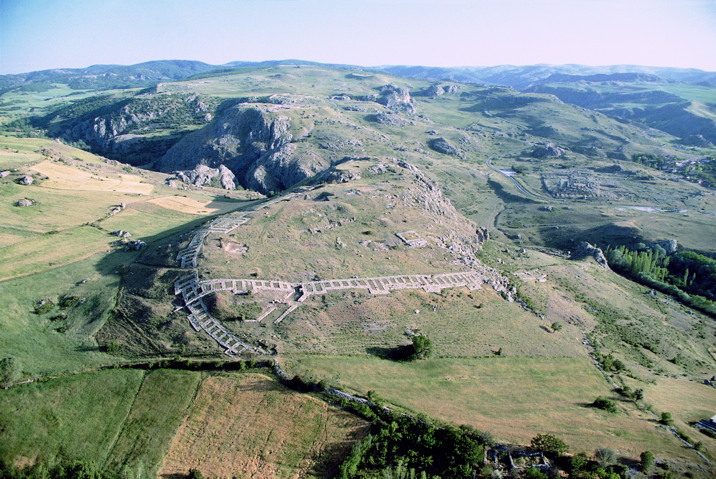
无论古今,对于一般游客来说,城市设计的独特性在于大门,它沟通了城里和城外的联系。门在古代近东所有文化中都具有某种神秘性。所以,上城防御要塞的门上饰有狮子或神像浮雕,既有装饰又有祈求保护作用,门通道呈抛物线形,这在欧亚非大陆是独一无二的(见图8)。
古城南部是人工建造的壁垒叶尔卡佩(土耳其语:大地之门),长约250米、底宽约70-80米、高约40米,其上又修建了防御工事(见图7)。在中心设有一个人行门,门上装饰有四个狮身人面像。与古城大门类似,叶尔卡佩壁垒独特的建筑结构代表了赫梯文化的权力和政治意识形态。此建筑结构有意建立在古城的最高点,在20公里以外距离就能看得见,从而展现其效果和政治意识形态。
公元前14世纪中叶为古城发展最鼎盛期,占地面积约190公顷。长期以来,现代学者一直认为公元前13世纪下半叶时城市规模开始下降,随后突然崩溃。最近的考古发掘提供了证据,证明这是一个更漫长、更复杂的发展过程,至今仍未被完全了解。根据墙壁的损坏状态(见图6),过去两年中在下城发现的大型建筑可能在公元前14世纪毁于地震(见图6)。一些出自纪念性建筑的证据也表明发生了大地震,所以这可能是解开赫梯帝国崩溃之谜中的第一步,但仍需进一步研究。
已知的考古、历史文献学及地理文献将公元前13世纪浓缩成一系列复杂的原因和事件,包括公元前1180年左右赫梯帝国的崩溃。国内政治动荡、气候条件的逐步恶化、安纳托利亚境内的人口迁移以及整个地中海东部人口的流动等都是可能存在的因素,但可能还有其他我们尚未了解的复杂相互作用打破了维持超过赫梯帝国450年的脆弱平衡,最终导致了赫梯帝国的突然崩溃。值得注意的是,安纳托利亚中部的赫梯文化在随后的铁器时代的物质文化中几乎没有留下任何痕迹,据此可以认为,它几乎不会影响该地区长期以来形成的文化地理根基。
在历经了深刻的文化退化之后,博阿兹考伊紧随赫梯帝国发展起来。令人惊喜的是,它是安纳托利亚中部铁器时代少数聚落考古发现之一,也是铁器时代的具有鲜明特色的彩绘陶在安纳托利亚起源的典型代表。公元前10~前9世纪后,当地陶器多样化的发展明显融合成一种本地风格和纹样。尽管我们不知道博阿兹考伊在铁器时代的确切名称,但该聚落缓慢的发展,于公元前8世纪成为了城市中心,已发现的巨型建筑及毗邻的防御工事体现出权力的等级。公元前7世纪~前6世纪,号称“南堡”的建筑标志着铁器时代社会进一步的发展。
这一时期的物质文化的发展具有本土化特征,几乎没有更广阔区域的文化影响,也可能是该地区的地理位置较为偏远的缘故。在被罗马帝国同化后不久就衰落了。最近几年的考古发现填补了该聚落历史的一个关键性空白。最初,罗马人在公元1世纪的时候建立了一个军营,可能与公元前3世纪晚期第一个城市的建立有着相同的地缘政治背景:控制交通路线。到了公元2世纪,营地为精心设计的郊区住宅和疗养地取代,并建有大型浴场和宴会厅。宴会厅装饰了最精良的壁画(见图9)。公元4世纪后期,部分建筑群开始使用,考古学上的明显变化和扩建也证明了这组建筑群的地方风格。
不知什么原因,这个聚落在公元4世纪末期分崩离析。直到公元10-11世纪的拜占庭时期,在前赫梯上城考古发现的一个保存完好的小村庄昭示着该地区的复兴。在这里,安纳托利亚人可能出于对安全需求的渴望,定居地点的频繁改变使定居史变得清晰了。当土耳其人移民到安纳托利亚后,此村庄就被废弃了,但也因此得以保存得如此完好。 直到公元16世纪博阿兹考伊小村庄在此建立(1982年改名为博阿兹考伊村);这一次,村子还是选在了山谷中。
在长期以来的地理条件相对不变的情况下,这种曲折的定居历史使我们有可能通过比较既定的常数和创新来判断不同时期不同文化的发展。 这样,就可以清楚地认识到,人类活动在何种程度和条件下能够影响社会文化发展,以及自然环境对人类社会文化活动的限制在哪里。
为未来保留过去
与考古发掘一样,德国考古研究所修复从教科文组织世界遗产遗址内出土文物的意义也十分重大。他们的修复目标是人们可以按年代在基本完整的自然环境背景中体验考古遗址。彼得·内夫为哈图莎什开发了一种理想的参观流程,非常适合当地恶劣的气候条件,哈图莎什现在可以作为露天博物馆而活跃起来了(见图7)。保护修复已发掘的建筑物,使参观平面图通俗易懂,配备赫梯宫庙建筑石雕复制品(见图8),有意识的提示参观重点,这种方式常见于土耳其各类博物馆。重建的部分赫梯城墙与原来的建筑形态十分接近,因为修复追求的是:使游客能够体验青铜时代的城市(见图10)。
个人简介:
安德烈亚斯·沙赫纳出生于1967年,是德国考古研究所伊斯坦布尔部的高级研究员、德国维尔茨堡大学近东考古学的副教授。1999年获得博士学位,在读期间曾参加过土耳其和乌兹别克斯坦的多项考古发掘工作。在慕尼黑大学近东考古学系担任助教时,独立在土耳其东南部开展了两个研究项目。2006年起,主持德国考古研究所博阿兹考伊的考古发掘工作,主要侧重于赫梯文化和古聚落历史的研究。哈图莎什研究最大的特色在于采用了多学科合作研究的方法,注重人文科学、各种自然科学与考古学结合研究的应用。安德烈亚斯·沙赫纳的研究不仅仅局限于考古发掘,研究领域还包括了安纳托利亚高原青铜时代和铁器时代、高加索、叙利亚和美索不达米亚,以及近东考古历史学和遗产保护、管理。他的出版物不只是关于田野考古工作,还涉及了古代近东艺术的理论和方法论、考古资料分析以及古代人类与地理环境之间关系。
With the finding by the Frenchman Ch. Texier of the ruins of an extended ancient city situated near the Central Anatolian village Boğazköy in 1834, the adventure of exploring one of the largest cities of the Ancient Orient began. The reliefs of the nearby open-air rock sanctuary of Yazılıkaya, which were always visible, pointed out the uniqueness of these monuments through their iconography and style. However, it was not until the first large-scale and systematic excavations, which were conducted jointly by the Ottoman Museum in Istanbul and the German Orient Society from 1906 to 1912, that the site was identified as the Late Bronze Age Hattusha, the capital of the Hittite Empire. This identification made it clear for the first time that an ancient oriental high culture could also develop outside the river regions of Mesopotamia, Egypt or the Indus Valley, under the relatively unfavorable geographical conditions of the Anatolian highlands (Fig. 1); a discovery which represents an essential paradigm shift in the archaeology of the ancient Near East.
Since 1931, the archaeological research at this site has been carried out continuously by the German Archaeological Institute, directed by Kurt Bittel (1931-1939, 1952-1977), Peter Neve (1978-1993), Jürgen Seeher (1994-2005) and Andreas Schachner (2006-present). The discovery of more than 30.000 fragments of cuneiform tablets that were almost entirely written in the Indo-European Hittite language (a discovery made by Bedrich Hrozny in 1915) led to the establishment of an independent branch of ancient oriental studies, Hittitology. Thanks to more than a century of closely interlinked research, fascinating insights into the history, social structure, material culture and religion of one of the most important superpowers of the Late Bronze Age in the Near East are possible. The combination of spectacular results from excavation and historical and linguistic research has brought a completely forgotten culture back into human memory, and led to Boğazköy/Hattusha being listed on the UNESCO world cultural heritage list since 1986. The archives of cuneiform texts found here are inscribed on the documentary heritage list, Memory of the World Register of UNESCO since 2001. Boğazköy is thus the only place represented on both of these important heritage lists.
Until the 1970s, research concentrated largely on the old city (Lower City) of the metropolis. In addition to the heavily fortified royal citadel (Büyükkale) (Fig. 2), the main focus was on the Great Temple (Fig. 3) and residential buildings in the Lower Town as well as the oldest fortifications. It became clear how the city gradually developed into the capital of a major empire after its foundation in the late 3rd millennium BC. The relocation of the work by P. Neve to the Upper City (1978–1993) and the extensive uncovering of more than 30 temples in a topographically defined part of the city significantly changed the image of the city, despite later corrections in dating. Today, thanks to the work of J. Seeher (1994-2005), we know that as early as the mid-16th century BC the Upper City was largely designed according to criteria of public representation and power representation. At the same time, the works of J. Seeher made an essential contribution to the understanding of the economic supply of the metropolis by providing evidence of various artificial water reservoirs as well as several monumental grain silos.
The underground granaries were constructed and controlled by the central institutions of the state. They made it possible to store large quantities of grain over long periods of time under vacuum-like conditions, thus bridging regularly occurring crop failures. The grain stored here served less to supply the population than to feed livestock and as seed for restarting the agricultural cycle. The artificial water reservoirs, of which at least nine can be found in the city alone, had a similar function (Fig. 4). They were dug into the slopes in such a way that at their bottom water-impermeable layers occurred but that on their back they intersect the groundwater levels rising and falling in the annual cycle, so that during the winter months the water was led into the ponds. This long-standing water could hardly be used for consumption by the population, but it ensured the supply of large herds of animals and made water-intensive handicraft enterprises possible.
These outstanding engineering achievements, which can be observed in a similar form in numerous Hittite cities in Anatolia, laid the foundations for the transformation of the Hittite royalty with local influence in the 17th and early 16th centuries BC into a great empire of supra-regional importance in the course of the later 16th to 13th centuries BC. Parallel to these technical innovations, social novelties such as the adoption of the Syro-Mesopotamian cuneiform script for the Hittite language, the homogenization of religion, and the creation of an iconographically and stylistically uniform art as a medium for conveying the ideology of the central state led to a more efficient organization and control of society as a whole (Fig. 5).
For a long time, the decades-long works conveyed the image of a supposedly linearly developing city. Only recently has it become clear that the history of the city is marked by several profound historical turning points and breaks. The foundation of the first settlement as a complex city ex nihilo in the late 3rd millennium BC, appears in the light of recent research in other areas of Anatolia, but especially in Kültepe, as part of the expansion of an exchange system between Anatolia, Syria and Mesopotamia. In this network, Hattush, as the city was originally called, occupies a strategically important, geographically defined junction, which to this day enables the connection between the north and the center of Anatolia. It is therefore not surprising that in the 19th and 18th centuries BC Assyrian merchants settled here, as in various other cities in Central Anatolia, and founded a “colony” that was part of a trade network that had its core in today’s Iraq. Although known for a long time, in the last two years for the first time a building of this period was uncovered, which is to be attributed to the royal administration and permits due to its extensive deposits an insight into the economic power of the rulers (Fig. 6). A very rare example of a diplomatic cuneiform text moreover shows the political development of power of the rulers of Hattush.
The transition from the time of the Assyrian trade colonies (c. 1950-1730/20 BC) to the Hittite period was not, as had long been assumed, marked by a hiatus of about 80 years. Instead our findings show that the settlement continued to exist in a significant size despite the archaeologically visible destruction by Anitta (around 1728 BC). The Hittite dynasty, which seized power around the middle of the 17th century with Hattushili I, therefore did not settle in an abandoned ruin but in a functioning town. Nevertheless, the beginning of a new political age is clearly visible from an archaeological point of view. Whereas everyday material culture developed linearly, new excavations and re-evaluations of older findings have shown that the Hittite rulers began very early to reshape the old town according to their ideas and socio-cultural necessities. This is particularly visible in the implementation of indigenous Anatolian monumental architecture, which is obviously different in structure and use compared to that of the Assyrian Trade Colonies period. The most impressive examples of this development during the late 17th and 16th centuries are the royal castle and the Great Temple (see Fig. 2 and 3). At the same time, the already mentioned water and grain reservoirs laid completely new economic foundations, which to a certain extent compensated for the uncertain geographical conditions in Central Anatolia.
With the construction of the Upper City (from c. 1530 BC) Hattusha not only reached a size corresponding to the contemporary capitals of Mesopotamia and Egypt, but also a corresponding representative design and effect (Fig. 7). The more than 30 temples formed a self-contained district that likely served to guarantee the ritual presence of the great king of “the empire of the 1000 gods”, as the Hittites called themselves. In addition, buildings on high rocky plateaus apparently played an important role, as these probably served the ancestor worship of the deceased and deified kings as indicated by textual evidence. But, their establishment, care and regular sacrifices were at the same time an important part of the legitimation of the ruling kings.
For the general visitor, in antiquity as well as today, the uniqueness of the city’s design is particularly evident in its gates, i.e. in the places which allow the connection between inside and outside, and therefore had a certain mystical function in all cultures of the Ancient Near East. The monumental gates of the fortifications of the upper town are not only decorated or protected by high reliefs of lions or a god, but their passages are also parabolic in shape, which is unique in the Old World (Fig. 8).
The south of the city is dominated by the c. 250m long, c. 70-80m deep and up to 40m high, artificially filled rampart of Yerkapı, over which the fortification runs (see Fig. 7). At its center a pedestrian gate is located, which is decorated with four sphinxes. Similar to the city gates, Yerkapı represents the power and ideology of Hittite culture through its unique architecture. The structure was deliberately erected on the highest point of the city, in order to be visible from a distance of up to 20 km and thus unfold its effect and ideological meaning.
This peak of the urban development, in which the city probably covered an area of almost 190 hectares, lasted until the mid, maybe late 14th century BC. It was assumed by modern scholarship for a long time that the decline only began in the 2nd half of the 13th century BC, but then led to an abrupt collapse. Most recent excavations provide evidence of a much longer and much more complex development which is still not fully understood. A large building that we have uncovered in the lower town in the last two years could have been destroyed by an earthquake according to evidence of damage patterns to the walls (see Fig. 6), probably in the course of the 14th century BC. There is also evidence of a massive earthquake in some of the monumental buildings, so this may be a first piece in the puzzle of the collapse of the Hittite Empire. However, the research is still ongoing.
The known archaeological, textual-historical and geographical references condense in the course of the 13th century BC to a complex bundle of reasons and events, at the end of which (around 1180 BC) the collapse of the Hittite Empire stands. Domestic political unrest, a gradual worsening of climatic conditions, population shifts within Anatolia and migratory movements in the eastern Mediterranean in general are only some of the possible causes which, in a complex and still not fully understood interplay, led to the sudden collapse of the fragile equilibrium which the Hittite state was able to maintain for more than 450 years. It is remarkable that the Hittite culture in Central Anatolia left practically no traces in the material culture of the subsequent Iron Age, from which one can conclude that it could hardly influence the long-term cultural-geographical foundations of Central Anatolia.
Boğazköy is one of the few places in Central Anatolia where the settlement of the Iron Age, after a profound cultural regression, immediately follows that of the Hittite period. Thus, it becomes clear that the characteristic painted ceramics of the Iron Age originated in Anatolia, contrary to earlier assumptions. Various local developments can be observed which have merged into a general style and iconography since the 10th/9th century BC at the latest. Even if the Iron Age settlement in Boğazköy, whose name we unfortunately do not know, developed only slowly, it become an urban center in which hierarchical power structures are evident in the 8th century BC by a monumental building and the adjoining fortifications. In the 7th and 6th century BC the construction of the so-called Southern Castle indicates a further step of the development of Iron Age societies.
The material culture of this period is characterized by a indigenous development, which hardly shows any influence of the cultures in the wider surroundings, maybe due to the geographical remoteness of the place. This pattern was only broken up by the integration of the region into the Roman Empire. Through the work of the last years a decisive gap in the settlement history was filled. At first a Roman military camp was founded in the course of the 1st century AD, probably against the same geopolitical background of control over the communication routes as the first city´s foundation in the late 3rd millennium BC. This camp was replaced in the course of the 2nd century AD by an elaborately designed villa and bathing complex, which was supplemented by a large water basin with a banquet room decorated with murals of the highest quality (Fig. 9). Although this complex was partly used until the late 4th century AD, its archaeological visible conversions and extensions prove the use of these buildings within a local cultural framework.
For unknown reasons the settlement breaks off in the late 4th century AD, to revive in the 10th – 11th century AD in Byzantine times through a small, but archaeologically uniquely well preserved village in the former Hittite upper town. In this selection of place, the frequent shift of settlement priorities in Anatolian settlement history becomes tangible, which was probably at least partly due to an increased need for security. This village was abandoned in the course of the Turkish migration into Anatolia, which is why it was so well preserved. It was not until the 16th century AD that the village Boğazköy (since 1982 Boğazkale) was founded; this time again in the valley.
Against the background of the longue duree, the geographical conditions have remained relatively unchanged. This eventful settlement history makes it possible to define for each period the defining parameters of the respective cultural development by comparing given constants and innovations. In this way, it becomes clear to what extent and under what conditions anthropogenic action was able to shape socio-cultural development and where the limits of human socio-cultural action were mainly set by the natural environment.
Preserving the Past for the Future
Parallel to the excavations, the restoration of the unearthed remains of this UNESCO world heritage site plays a central role in the work of the German Archaeological Institute. The aim of these efforts is to make it possible to experience the site in all its chronological facets, embedded in a largely intact natural environment. P. Neve has developed a work-flow ideally suited to the harsh local weather conditions, thanks to which Hattusha can now be actively experienced as an open-air museum (see Fig. 7). In addition to a restoration that protected the excavated buildings and make their ground plans visible at the same time, visitors can see installations of replica monumental Hittite stone sculptures (see Fig. 8), actually stored in various museums in Turkey. The reconstruction of a section of the Hittite city walls, which is largely true to the original, pursues the same goal: to enable visitors to experience the Bronze Age city (Fig. 10).
Biographic Sketch
Andreas Schachner (born 1967) is a senior research associate at the German Archaeological Institute´s Istanbul Section and an adjunct Professor for Near Eastern Archaeology at the University of Würzburg, Germany. After having participated in various excavations in Turkey and Uzbekistan during his education (PhD in 1999) he conducted two independent research projects in Southeastern Turkey while working as an Assistant Professor at the Department of Near Eastern Archaeology of Munich University. Since 2006 he directs the German Archaeological Institute´s Boğazköy Excavations focusing not only on the Hittite remains but taking the settlement history as whole into account. The research in Hattusha is characterized by an interdisciplinary approach that combines humanities and methods of various natural sciences and attaches particular importance to the application of archaeometric research. Beside his excavation responsibilities Andreas Schachner´s research interests cover a wide range of mainly Bronze and Iron Age topics reaching from the Anatolian Highlands to the Caucasus, Syria and Mesopotamia, but also the history of archaeology in the Near East as well as issues of heritage conservation and management. His numerous publications deal not only with his fieldwork but contribute to theoretical and methodological aspects of the Ancient Near Eastern art, archaeometric analysis of materials as well as various aspects of the relationship between humans and their geographical environment in Antiquity.